Border
Environment Cooperation Commission
Delta
Lake Irrigation District (Edcouch, Texas)
Water
Conservation Improvement Project
1.
Project Type
The proposed project fall
under the Border Environment Cooperation Commission (BECC) priority area of
water conservation. The proposed project consists of four priority water conservation
project components that were selected from a list of 11 major and 37 minor
needs of the Delta Lake Irrigation District (DLID) system. The four project components include 1)
reservoir renovation, consisting of
construction of a 17,000 linear foot bypass canal along the eastern edge of
Delta Lake, 2) a 3-mile pilot seepage
recovery system for the main canal, 3) installation of a flow measurement and
telemetry system at 20 water
diversion points to control and monitor deliveries, and 4) replacement of
approximately 16.8 miles open channel laterals with pipes. Given that the Rio Grande is the District's only anticipated water
source, and the Districts goal is to maximize efficiency, the proposed
activities
will improve management and conservation of water, reduce evaporation, seepage
losses and operation and maintenance costs, and will conserve energy.
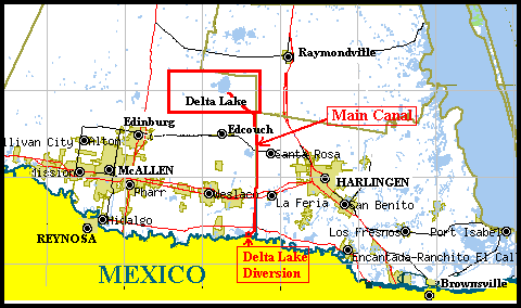
2. Project Location
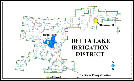
DLID was originally established in 1914. It is
located in the Nueces-Rio Grande basin northeast of Edinburg, Texas, in Hidalgo
and Willacy Counties. The District is within 62-miles from the Rio Grande River
U.S.-Mexico border and the Rio Grande River is the only source of water for the
district. The District has an irregular shape covering 148.95 square miles
(95,328.8 acres), with its southern boundary located about 1.5 miles north of
Edcouch, Texas, and extending north and northeast including the cities of
Hargill, La Sara, Monte Alto and part of the City of Raymondville.
The Districts main landmark is Delta Lake, with a
capacity of 25,000 acre-feet of water and a surface area of 2,371 acres. The
lake was constructed in 1939 for District storage of water diverted from the
Rio Grande River to regulate and assure adequacy of water for irrigation
requirements. The lake assures a more constant and reliable availability of
water to meet District needs, considering the four-day travel time of water
from Falcon Reservoir. The lake is separated by a roadway that divides it into a
smaller West Reservoir and a larger East Reservoir. The two reservoirs are
connected via a culvert running under the dividing roadway and can be isolated
from one another using a valve.
Water
is diverted from the Rio Grande River in Hidalgo County near the Hidalgo and
Cameron County line at the Rio Grande River.
Water is pumped into a main canal where it flows by gravity
approximately 32 miles to the southeast corner of Delta Lake. Water is
distributed to land from the canal during the irrigation season or to a pumping
plant that lifts surplus water to Delta Lake for storage. When needed for
irrigation, water is released from the lake and flows back to the main canal
for distribution. The District water supply system consists of 250 miles of lined
or partially lined canals, 42 miles of unlined canal and 122 miles of unlined
laterals.
The District has the second largest area of the 28
Districts in the Rio Grande Valley, with authorized irrigation water rights of
174,776 acre-feet, 3,999 irrigation accounts and
70,000 acres in irrigation. In addition to irrigation water rights, the
District also has annual municipal and industrial water rights of 9,520
acre-feet. The District system provides water to the cities of
Raymondville, Hargill, La Sara, Monte Alto, and Lyford, including rural
homeowners, as well as Santa Maria Irrigation District Cameron County No. 4, La
Feria Irrigation District Cameron County No. 4, Valley Acres Water District,
Hidalgo and Cameron Counties District No. 9 and Hidalgo County. The Districts 5-year average annual water
diversion was 80,944 acre-feet for 1998 to 2002. The Districts 5-year average
annual water diversion for irrigation is 75,704 acre-feet per year and 5,240
acre-feet per year for municipal and domestic water use. The District reports
an estimated water delivery efficiency of approximately 63%. A location map of the
District and layout drawing are shown below.
3.
Project
Description and Work Tasks
The project includes 4
priority components selected from a review of a list of 11 major and 37 minor
projects identified throughout the District's water delivery system. The
estimate of the quantity of water that
will be saved from the four components combined is 13,808 acre-feet per year,
and the annual energy savings is estimated at 741,614 KWH. The estimated completion time for the work is 28 months
from approval of the project for funding. The
following is a brief description of each of the four components of the project.
Reservoir Renovation
The reservoir renovation component of the project
will consist of the construction of a 7,000-foot long by-pass canal beginning
at the southeastern corner of the East Reservoir where the main canal supplies
the lake, running along the east shoreline of the reservoir and terminating at
a pump house along the reservoir's north-northeast edge. The purpose of the canal is to be able to
by-pass the lake and be able to provide irrigation and domestic water to the
northern and eastern portions of the District, including the cities of
Raymondville and Lyford, without having to store that water in Delta Lake. Constructing the
proposed bypass canal will reduce the seepage and evaporation losses associated
with transporting water through the East Reservoir of Delta Lake. Under the current system, raw water is transported to these areas
via the Delta Lake, and it has been estimated that in a dry summer month, over
1,700 acre-feet of water are needed to be placed in the East Reservoir to
deliver about 400 acre-feet at the northeast corner. This is a loss rate of
approximately 77 percent, mostly evaporation.
The proposed by-pass can save a substantial amount of water, and if
current drought conditions continue and expected future decreases in water
supplies occur, the delivery of raw water through
Delta Lake will not be possible. The projected annual savings of water for this component is
2,685 acre-feet, and the estimated cost of this component is $1,236,675.
Main Canal Seepage Recovery System
This component of the
project includes construction of a pilot 3-mile surface and subsurface drain
collection system and return pump to collect water that seeps from the main
canal. The capital cost of such a
recovery system is much more economically viable than concrete lining the main
canal due to the length of the canal.
In addition, the
energy required to pump the recovered seepage back into the main canal will be
approximately 25% of the energy required to pump water from the Rio Grande, or
for every acre-foot of seepage water that is salvaged, the District will reduce
energy cost per acre-foot by 75%.
A 5 cfs (cubic feet per second) seepage recovery
system is proposed, consisting of a subsurface telescoping toe interceptor
drain running adjacent and parallel to the banks of the main canal and a low
head lift station to pump the water back into the canal. After construction, a
monitoring system will be established to track the actual loss rate from the
canal, the quality of the water recovered and the ability to collect and return
the lost water back to the canal to plan future seepage collection activities. The projected annual savings of water for this component is
2,280 acre-feet, and the estimated cost for this component is $469,264.
This component, along with
the rest of the 32-mile long main canal from the Rio Grande River (the Willacy
Canal), is within the Otha Holland Wildlife Corridor. A Cooperative Management
Agreement between the District and the U.S. Fish and Wildlife Service was
signed on June 7, 1990 in order to eliminate illegal dumping and trespassing on
the land, while preserving and protecting wildlife habitat along the length of
the canal. During construction of the drain collection system, no land
dedicated to public use (including wildlife management) is expected to be
unreasonably impacted by the proposed construction, and in fact, the seepage
recovery system will help preserve the habitat corridor compared to lining the
canal.
Telemetry and Flow Measurement
This component consists of the installation of flow measurement devices at 20 diversion
points within the Districts water supply system. These devices will be
permanently installed to monitor deliveries into particular laterals of the
system and send this information, by telemetry, to the District headquarters.
This information will allow the District to track and control water usage,
identify where losses are occurring and allow the District to forecast and
provide for future water uses. By having more real-time information, the District
can operate the system more efficiently. The projected annual savings of water
for this component is 2,650 acre-feet, and the estimated construction cost for
this component is $510,180.
Canal Rehabilitation
The canal rehabilitation component includes replacement of
approximately 16.8 miles of existing concrete lined canals with buried 12, 18,
24, 36, 42 and 48-inch pipelines. The 36, 42 and 48-inch will be reinforced
concrete pipe (RCP), and the smaller diameters will be PVC (polyvinyl chloride)
pipe. Most of the pipelines to be installed will be 24-inch PVC. The first 3.4
miles of pipelines are fully designed based on a detailed hydraulic study using
EPANET software. This information was used to prepare estimates of the balance
of the canals identified for replacement with pipes, but which have yet to be
fully designed.
This component will save water by reducing seepage
and evaporation losses and their associated pumping requirements and costs.
Also, the control of water and flow rates delivered to individuals will be
improved and can allow for a greater number of fields to be simultaneously
irrigated. The
projected annual savings of water for this component is 6,193 acre-feet, and the estimated construction cost for this component is
$3,605,355.
4.
Conformance with
International Treaties and Agreements
The
International Boundary and Water Commission (IBWC) is an independent
bi-nati2onal public organization that ensures implementation of the 1944 Water
Treaty between the United States and Mexico related to water and boundary
issues. The project does not violate the allocation of water rights. The
District will continue to meet all state surface water diversions from the Rio
Grande in accordance with the agreements in place and the restrictions of the
Treaty.
The
Texas Commission of Environmental Quality (TCEQ) and the International Boundary
and Water Commission (IBWC) are the authorities for allocation of water to the
District. The 1944 Water Treaty between
the United States and Mexico applies.
DLID diverts water from the Rio Grande River in accordance with a Permit
issued by TCEQ, governed by Chapters 49 and 58 of the Texas Water Code and
Article XVI, Section 59 of the Texas Constitution. TCEQs Rio Grande Watermaster
Office in Harlingen is responsible for allocating, monitoring, and controlling
the use of surface water by the District in coordination with IBWC. The State
Watermaster also cooperates with IBWC and its Mexican counterpart to monitor
U.S. and Mexican compliance with the U.S.-Mexico Treaty of 1944. There is no
reported non-compliance by the District under the TCEQ permit.
Human
Health and Environmental
1. Human Health and Environmental Need
The proposed project activities address one of the most pressing
problems facing the Lower Rio Grande Valley of Texas, i.e., water shortages due
to drought over the last seven years and an increasing demand due to population
growth. Water conservation reduces the impact of drought conditions and makes
available additional water resources that would otherwise be lost to meet both
domestic and agriculture demands. The future health, social and economic well
being of the population in the Rio Grande Valley will be dependent on
conservation and maximizing beneficial use of available water to meet domestic
and agricultural needs. The project addresses the critical water shortages by
reducing water losses and providing for more efficient delivery of water, thus enhancing
availability of water both domestic and agriculture use.
2. Environmental Assessment
An Environmental Summary
(ES) for the project was completed by Axiom-Blair Engineering. Preparation of
ES utilized information for a wide variety of sources including the TCEQ, the
U.S. Census Bureau, the U.S. Fish and Wildlife Service, the Texas Parks and
Wildlife Department, the Texas Historical Commission, the National Weather
Service, the U.S. Soil Conservation Service, the Texas Department of
Transportation and on-site field reconnaissance.
The ES resulted in the
following conclusions:
§
The
need for the project is real and immediate.
No reasonable alternatives exist to the recommended alternatives.
§
No
short or long term detrimental socioeconomic effects are expected as a result
of the project. Socioeconomic impacts
are expected to be wholly positive.
§
Short-term
wildlife habitat disturbance associated with the project will be moderate;
however, long-term disturbance is expected to be minimal to none.
§
No
significant, long-term air, water or vegetative impacts are anticipated.
§
No
cultural resources will be impacted as a result of the proposed project.
§
From
a regional perspective, this Water
Conservation Improvement Project is expected to have a positive impact from environmental and socio-economic perspectives, and no
impact on cultural-historical resources.
The ES was
submitted to the Texas Parks and Wildlife Department, Texas Historical
Commission, U.S. Army Corps of Engineers and the United States Fish and
Wildlife Service for review. The U.S. Army Corps of Engineers has determined
that since the project sites do not contain any areas subject to Section 10 of
the Rivers and Harbors Act or Section 404 of the Clean Water Act, a Department
of the Army permit is not required. The Texas Historical Commission reviewed
the project under Section 106 of the National Historic Preservation Act of 1966
and the Antiquities Code of Texas and determined that the project should have
no effect on historic properties. No further review is necessary from the
Texas Historical Commission. Additional comments received from the U.S. Fish
and Wildlife Service and the Texas Parks and Wildlife Department have been
addressed through correspondence and additional specifications were added to
the construction
drawings.
Regardless of these jurisdictional determinations,
it is the Districts goal to protect the environment and its inhabitants. The
construction drawings include specifications requiring the contractor to
protect existing waterways, vegetation and wildlife from unnecessary
disruptions during construction. In addition, the District will file the
required Notice of Intent with the Texas Commission on Environmental Quality
(TCEQ) and prepare a Storm Water Pollution Prevention Plan prior to
construction.
The construction of the proposed water
conservation measures will have an overall sustained positive environmental
impact, enhancing the prospects for continued economic growth of the region, as
well as the improved health and social well being of the regions growing
population.
3. Compliance with Environmental and Cultural
Resource Laws and Regulations
The environmental review of the project and the
proposed mitigation measures comply with all environmental and cultural resource
laws and regulations. All required permit conditions
necessary for the construction or operation of the proposed project will be
acquired and complied with. The District has the required water rights
and is fully compliant with the terms of its water use permit.
1.
Appropriate Technology
The Project Plan for the project was completed by
Axiom-Blair Engineering in accordance with USBOR guidelines, funded by the Texas
Water Development Board (TWDB) State Energy Conservation Office (SECO) funds.
The Project Report, also being funded by SECO funds, is being finalized for
TWDB approval. As stated earlier, the four project components were selected
from a review of a list of 11 major and 37 minor projects identified throughout
the District's water delivery system. Each of the four project components was
analyzed with consideration of most appropriate technical and least-cost
alternative, as described below.
Reservoir
Renovation
Four potential
project alternatives were identified and analyzed; 1) construction of a new
canal and associated improvements, 2) construction of a 24-inch
transmission main, 3) construction of a 36-inch transmission main, and 4) the
no-build alternative. Preliminary cost estimates for the 24 and 36-inch
transmission mains were estimated to be from 2.2 to 4.6 times the estimated
cost of the new canal. Both pipeline alternatives would require significant
clearing along the same general alignment proposed for the canal. Although
these widths are roughly half of that required for channel construction, a
clear-cut swath would still be required through the project alignment.
Additionally, the transmission capacity of the pipelines is extremely limited
(12 to 27 percent) relative to the canal alternative. No overwhelming benefits
were identified that justified the additional cost and limited capacity of the
transmission main alternatives. Construction of either transmission main was
therefore eliminated as a viable alternative.
Numerous potential negative impacts are
associated with the no-build alternative. Severe curtailment of water use
would be required resulting in damage to small-scale agriculture, lawns, trees,
landscaping, etc. The Development of emergency interim water supplies would be
necessary resulting in increased cost, fuel usage, air pollution and traffic.
There would also be a higher potential for public health and safety problems
typically associated with inadequate water supplies including loss of system
pressure, system contamination, longer distribution system residence times,
etc. As a result of the significant potential negative impacts, the no-build
alternative was eliminated from consideration. Construction of a bypass canal and
associated improvements was therefore selected as the recommended alternative.
The proposed bypass canal will be
constructed along the inner edge of the eastern embankment, utilizing the
existing berm. The western embankment will be constructed from material dredged
from the bottom of the reservoir. The trapezoidal cross section has a five-foot
bottom width, 2:1 side slopes and has been designed to carry a minimum flow of
66 cfs (cubic feet per second). The bypass canal will not be lined in conjunction
with this project. Control structures have been designed to accommodate the six
existing diversion points along the eastern edge of the reservoir. Radial gates
will be installed at the Main and J Canals to provide better flow control.
The radial gates at the Main Canal will allow the East Reservoir of Delta Lake
to continue to be utilized as a reservoir for the District, but in an
off-line instead of in-line capacity. The proposed control structures will
allow the steady flow of water to the bypass canal and excess water will be
diverted into the East Reservoir. In times of extreme water shortages, this
system will allow the District to still provide domestic water when lake levels
are low. Appropriate control gates, weirs and concrete wells will allow the
flows to be measured and controlled, and concrete flumes will be constructed
along the bypass canal upstream of each of the control structures and flow
measurement devices will be installed at each of the diversion points. These
flow measurement devices will be connected to the proposed telemetry system.
Seepage Recovery System
The main canal (the Willacy Canal and
the Otha Holland Wildlife Corridor) is 32 miles long with a typical trapezoidal
cross-section consisting of top surface of about 80 feet wide, a base of 40
feet wide and a 1:1.5 side-slope ratio. Because of the size of the canal,
concrete or urethane lining is prohibitively costly, and would directly impact
the wildlife habitat. The proposed seepage recovery system is considered the
best alternative to lining.
A feasibility study was performed to
determine the most economical region of the project study area to recover
seepage water. The project study area was defined as the entire length of the
Willacy Canal from the Rio Grande to Delta Lake. The Soil Survey of Hidalgo
County, Texas, the Soil Survey of Willacy County, Texas and the Soil Survey of
Cameron County, Texas, published by the United States Department of
Agriculture, Soil Conservation Service in cooperation with the Texas
Agricultural Experiment Station, were consulted to determine the general soil
characteristics of the study area. According to the Surveys, soils along the
Willacy Canal range from clay, with a low permeability rate of less than 0.06 in/hr,
to fine sandy loam, with a permeability rate between 0.6 to 6.0 in/hr. A
three-mile length of canal was selected for the feasibility study area, due to
its soil characteristics and its identification by District personnel as a high
seepage area.
Once the feasibility study area was
identified, a geotechnical engineering firm was hired to perform borings at
regular intervals along the embankment and adjacent roadway to determine the
actual permeability rate, the depth of the water table and the quality of the water
in the canal and the borrow ditch. This information was utilized to design the
subsurface telescoping toe drain system and a 5 cfs pump station to pump the
recovered water back into the Willacy Canal. The location of the site is near
the southeast corner of the District. The capital cost of such a recovery
system is estimated to be 5 to 10 times more economically viable than concrete
lining the main canal.
The activity will include the establishment of a monitoring
system to accurately measure results for the possibility of future work to
expand collection of water that seeps from the main canal and pumping it back
into the system.
Telemetry and Flow Measurement
The 20 diversion structures for the
installation of the measurement devices were designed with one or multiple
measurement devices depending on the structures located on the site. Each of
the measurement devices on the individual sites will be connected to a single
telemetry system. The diversion structures can be broken into two categories,
pump houses (closed conduit flow) and check structures (open channel flow). At
all of the pump house sites, water is drawn from the supply canal with single
or multiple pumps and discharged to a pump well. Once the water enters the pump
well it is distributed to single or multiple distribution lines for delivery to
the customer(s). Each pump well is constructed with a wall that acts an
overflow weir. If the pump produces more water than the customer uses, the water
fills up the well, eventually spills over the weir and flows through a recycle
line that returns excess water back into the supply canal. When small flows are
required, a valve at the bottom of the weir wall can be opened to allow water
to flow directly from the supply canal to the distribution line without the use
of the pump. With the present system, the District has no mechanism to
routinely quantify the amount of water a pump house is producing in relation to
the amount
actually delivered to the customer.
The District wanted a mechanism for
determining how much water each of the pump houses were producing so they could
compare this to the amount of water needed. In addition, they wanted to be able
to reduce the amount of water being recycled without constant visual
monitoring. It was decided that the flow from each pump would be metered with
either a run-time meter or a pipeline meter depending on the pump house
characteristics. Each of the pump well weir walls would be equipped with a
submersible pressure transmitter to monitor the level of the water in the well.
When the water level exceeds the height of the weir for a specified period, the
pump would shut off. Once the water level drops below the crest of the weir,
and the resting period has passed, the pump would again run.
Due to their reliability, accuracy and
suitability for the sites, saddle mount propeller meters were chosen to meter
the flow in the pump discharge line. Each meter will be protected from
vandalism and theft by either a lockable concrete or welded expanded metal
enclosure. Concrete enclosures will be constructed at sites where the discharge
pipe(s) are located below grade and welded expanded metal enclosures will be
constructed at sites where the discharge pipe(s) are located above grade. Sites
equipped with a propeller meter will also be equipped with a calibration port,
located upstream of the meter, to calibrate the meter with a portable flow
measurement device. At sites without sufficient pipe length to install a
propeller meter, a run-time meter will be installed on the pump to measure the
amount of time the pump is running. The pump characteristics will be utilized
to prepare a rating curve for converting the measured time to flow.
At each of the check structures, the
flow will be measured downstream from the check structure using a flow
measurement structure or device. The canals containing the check structures
could be divided into two categories; large (top width in excess of 20-feet),
earthen canals and small, concrete-lined canals. Based on their ability to be
computer calibrated using as-built dimensions, long-throated flumes were
selected for flow measurement of the small, concrete-lined canals. A
cross-section from the existing canal was utilized to design a flume for each
of the sites using the WinFlume software. Rating tables were prepared for each
of the flumes based on the proposed design. Once the flumes have been
constructed, as-built dimensions will be tables for use in determining flows at
different elevations. Each flume will be equipped with a submersible pressure
transmitter, housed in a stilling well, for determining the water level in the
approach section of the flume and a staff gage for visual verification. It was
decided that a velocity flow meter would be the most cost effective and
accurate metering device for the large earthen canals. A Doppler meter, which
measures velocity in the channel, will be installed at each of these sites. The
meter will be installed in a concrete slab constructed along one bank of the
channel. The slab will be located sufficiently downstream from the check
structure to minimize unsteady flow. The meter will measure the velocity of the
water and will be equipped with an integrated pressure sensor for water surface
level measurement. A rating curve will be developed for each of the canal
Doppler meter sites to determine the flow. The meters will be calibrated using
a portable metering device.
Three diversion points included in the
project did not fall into any of the above categories. The No.1, No. 2 and No.
3 Canals currently receive water from the East Reservoir of Delta Lake via a
pipeline through the existing embankment. Each of the existing diversion
structures will be removed and replaced with a concrete vault equipped with a
rectangular sharp-crested weir. A rating curve has been developed for each weir
and will be utilized, along with the water level, to provide the District with
flow data. This information will allow the District to control and measure the
flow into each of the laterals.
A telemetry system will be installed at
each of the 20 diversion points for the District to periodically, and on
demand, poll for data from the field devices (remote telemetry unit (RTU)),
process the data into a central data base (base computer), send controls to
field devices and display the data in useful formats to water operation
personnel. A Base System will be located at the District Headquarters and will
consist of a base computer, which will hold the central database to store and convert
all of the data from the RTUs, and an antenna to receive from and transmit data
to the remote telemetry systems. The base computer will be equipped with
software that will display current, last 24 hours and monthly water and flow
level data of any or all of the RTUs. It will also store all engineering and
conversion data necessary for converting flow. A remote telemetry system will
be installed at each of the flow measurement sites. Each system will consist of
the following:
Remote Telemetry Unit (RTU)
Radio and RF Modem
AC/DC Linear Power Supply
These items will be mounted inside a
steel enclosure on a panel with room for a storage battery to be placed on the
bottom of the enclosure. A radio antenna will be mounted on a 20-foot antenna
mast for transmitting and receiving data from the base system. At sites
equipped with a pump house, the telemetry system enclosure will be mounted
inside, on the specified wall, and wired to the existing power source. At sites
without a pump house, but where electricity is available, the telemetry system
enclosure will be installed in a steel vandal box and wired to the existing
power source. When electricity is not available, the telemetry system enclosure
will be installed in a steel vandal box and a solar panel will be added to the
antenna mast to provide power. Once the telemetry system enclosures are
mounted, the RTU will be wired to the metering device(s), the pressure
transmitter, the existing pump panel(s), solar panel and antenna, as specified
in the construction drawings. The system will then be programmed with the
calibration coefficients for each site and DLID personnel will be trained in
the operation and calibration procedures for the telemetry system.
Canal Rehabilitation
Four rehabilitation options were
considered for the damaged canal segments; relining with concrete, line with an
impervious liner, replace the canal with a pipeline or do nothing. Preliminary
cost estimates were prepared and revealed that replacing existing concrete
lining of the canals was 100 to 200 percent more expensive than lining the
canal with an impervious liner or replacing the canal with a pipeline.
Additionally, the soils in the area shrink and swell extensively in response to
moisture changes. No benefits were found to justify the additional cost and
future problems of installing new concrete lining. Replacing the existing
canals with concrete was therefore eliminated as a viable alternative.
According to an on-going study by Texas A&M University, concrete lined
canals similar in size and soil type can lose from 220 to 375 acre-feet/mile
per year of water due to seepage. An additional loss of 2.2 acre-feet/mile per
year on the open canals is also estimated due to evaporation.
With the ongoing drought and the Districts commitment to water
and energy savings, the no-build alternative was eliminated from consideration.
Both lining the canal with a polyurethane liner and replacing the canal with a
pipeline had the positive benefit of eliminating seepage and low maintenance
costs, but each had its limits on cost-effectiveness. It was found that at higher
flow rates, it was more cost effective to line the canal with a polyurethane
liner. At low flow rates, replacing the canal with a pipeline was more cost-effective.
Since both the liner and the pipeline would be installed along the existing
canal alignment, the environmental impacts of the projects would be very
similar. However, the segments selected for replacement are small laterals with
low flow rates and based on the above observations, replacing the canals with
pipes were determined the most cost-effective alternative.
A detailed hydraulic study for 3.4 miles
of canals proposed to be replaced with pipes was performed using EPANET
software to determine the flow requirements. Once the flow requirements were
determined, the study was utilized to determine the size for each pipe segment,
design and costs for this 3.4 miles. This information was also used to prepare
preliminary sizes and costs for the rest of the 13.4 miles of proposed
pipelines, including distribution pipelines, turnout pipelines and associated
concrete structures. The proposed project costs include final design and
preliminary estimated construction costs for the 13.4 miles of canal replacement
with pipes.
All proposed pipelines larger than
24-inches will be installed as reinforced concrete pipe (RCP) and those equal
to or smaller than 24-inches will be installed as polyvinyl chloride (PVC)
pipe. The pipeline will be installed in one of the embankments of the existing
canal, with its alignment parallel to the edge of the existing canal. A
concrete inlet structure will be constructed at the intersection of the
proposed pipeline and the supply canal. This structure will be located to ensure
the inlet of the pipeline will remain submerged and thus, ensuring the pipeline
will remain pressurized. A turnout connection box will be constructed at each
point of delivery along the alignments. These boxes will provide access points
for debris removal by District personnel. The line gates at each turnout can be
locked in place for the duration of the delivery once the flows have been
adjusted by District staff. This method allows for the use of portable flow
meters rather than having a flow meter at each point of delivery. A drain
pipeline will be provided at the end of each pipeline. Once the pipelines are
in place, the existing canal will be backfilled with material from each of the
embankments to provide a uniform slope across the District right-of-way.
2. Operation
and Maintenance Plan
The operation and maintenance
requirements for the improvements to the facilities are basically the same as
already performed on the existing pipelines and canals of the system. The existing staff are considered
sufficiently capable and experienced to undertake required maintenance of the
new pipeline and canal. Equipment
suppliers will be required to provide training on the operation and maintenance
of equipment, including provision of O&M manuals.
3.
Compliance
with Applicable Design Standards and Regulations
The
design and construction requirements will adhere to USBOR requirements under
the Guidelines for Preparing and Reviewing Proposals for Water Conservation
and Improvement Projects under Public Law 106-576. USBOR design standards and
criteria were applied and USBOR quality control procedures will be applied
during construction.
Financial
Feasibility and Project Management
1.
Financial
Feasibility
Axiom-Blair Engineering
prepared an analysis of project and the Districts financial condition to
provide matching funds for proposed funding structure of the project and the
operation and maintenance of the system. The estimated project costs based on
the design information are as follows:
PROJECT COSTS
|
ITEM |
FUNDING
SOURCE |
TOTAL |
|
Planning |
DLID & SECO |
$134,632 |
|
Design/Construction Contracting |
DLID & SECO |
$527,789 |
|
Construction Administration |
DLID |
$636,105 |
|
Construction Cost |
DLID, NADB & TWDB |
$5,821,474 |
|
TOTALS |
|
$7,120,000 |
Cost in U.S.
Dollars. August 2003
The
funding sources for the project are summarized in the table below. Based on the WCIF Guidelines, the WCIF grant
may support 50% of the project costs up to or a maximum of $4,000,000. The District is
currently negotiating a cost sharing agreement with North Alamo Water Supply
Corporation (North Alamo WSC) under the auspices of the Texas Water Development
Boards Disaster Contingency Fund program. North Alamo WSC has been awarded
$347,017 toward the excavation of the Delta Lake bypass canal proposed in the
Districts Water Conservation Project. Approximately $325,000 of the $347,017
is anticipated to be available to the District to provide for a portion of the
excavation cost of the bypass canal. The funding sources
for the projects are as follows:
FINANCIAL
STRUCTURE FOR THE PROJECT
|
Source |
Type |
Amount USD |
% Project Cost |
|
NADB |
WCIF-Grant |
$3,560,000 |
50% |
|
State
of Texas |
SECO Grant |
$253,020 |
3.5% |
|
TWDB Disaster Contingency Fund North Alamo
Water Supply Corp. |
Grant |
$325,000 |
4.6% |
|
DLID |
Cash & In-Kind |
$2,981,980 |
41.9% |
|
TOTAL |
|
$7,120,000 |
100% |
2.
Rate
Model
The table below summarizes the existing
structure.
Existing Assessment Fee Structure
|
Fees |
Per Acre |
|
Annual
Flat Rate (per irrigable acre) |
$10.00 |
|
Ad
Valorem Tax |
$0.54 per $100 valuation |
|
Water
Assessment (per
acre irrigated) |
$20.00 |
The proposed projects and funding source structures do not require
an adjustment to the current Fee and Assessment Structure implemented by the
District.
3.
Project
Management
The
project will be managed and implemented by DLID with engineer construction
administration support. The telemetry system and the seepage control component
are expected to be contracted, and the rest of the work is expected to be
undertaken via force-account. The District has managed construction activities
of similar magnitude. The District can operate in a
self-sufficient manner, supporting itself through user fees, but is expected to
apply for future potential USBOR grant resources for the project. The
existing organizational structure which has been provided is considered
sufficient and the project will not require additional District staffing,
except for additional labor only for the proposed force-account
construction. The Districts engineer,
Axiom-Blair Engineering, will provide the necessary technical and management
support for project administration.
1.
Comprehensive Public
Participation Plan
The Public Participation Plan submitted by
the DLID and the Project Steering Committee was approved on April 30, 2003.
2. Steering Committee
The Steering Committee was composed of Neal Galloway,
President, DLID Board of Directors; Eleazar Garcia, City Manager, City of
Raymondville; Chuck Browning, North Alamo Water Supply; and Max Phillips,
Manager, DLIC. As a result of the effectiveness of this steering committee,
public water users in the District understood and in the end supported the
benefits of the proposed project.
3.
Local Organizations
Steering Committee members contacted local organizations to
solicit their support. Chuck Browning
made a presentation for North Alamo Water Supply, Max Phillips made
presentations for the City of Edcouch
and the City of Monte Alto and Max Phillips and Eleazar Garcia made a
presentation for City of Raymondville.
DLID Board President Neal Galloway made presentations for Rio Farms,
Wetegrove Brothers, Inc., Charles Wetegrove Company, Inc., CRB Farms, Encino
Farms, Hargill Growers Gin and Hester Farms.
Letters of support for the project were received from Rio Farms,
Wetegrove Brothers, Inc., Charles Wetegrove Company, Inc., CRB Farms, Encino
Farms, Hargill Growers Gin and Hester Farms.
4.
Public Information
Project
information such as the Project Proposal, Project Plan, Step I Application and
draft Project Strategic Plan were available for review at the DLID
offices. A fact sheet was developed and
distributed to District water users and was made available at public meetings. Fact sheets were also available for walk-in
customers at the DLID office and were posted in local businesses. Notices of public meetings were published in
the McAllen Monitor.
5.
Public Meetings
1.
Definition
and Principles
Sustainable Development Criteria is defined as conservation oriented social and economic protection and sustainable use of resources, while addressing both current and future needs, and present and future impacts of human actions. This definition is based on the Rio de Janeiro Declaration on Environment and Development, which states that development should meet the needs of the present without compromising the ability of future generations to meet their own needs.
All of the proposed project
components will comply with the definitions and principals of
Sustainable Development in
that they positively impact the area and sustainable life of the areas residents
through the conservation of water. Water conservation is critical to quality
and life and economic growth in the Rio Grande Valley. The Reservoir
Renovation, Canal Seepage Recovery, Telemetry and Flow Measurements Sites, and
Canal Rehabilitation projects will help eliminate the seepage of valuable
water. In addition to water savings, local residents will experience energy savings
through a more efficient delivery system.
2.
Institutional and Human Capacity Building
The Rio Grande Regional Water Plan, in support for
the implementation of agricultural water conservation strategies, includes the
following actions for reduction of irrigation shortages:
·
Expanded
technical assistance should be available from local, state and federal sources
to assist irrigation districts with more detailed systematic evaluations of
district facilities and management policies to identify cost effective water
efficiency improvements.
·
The State of Texas and the federal
government should assist with the financing of irrigation water improvements
through the provision of low interest loans and grants
Accordingly, due to the limited financial capacity
if irrigation districts, the State of Texas through the State Energy
Conservation Office (SECO) and the Texas Water Development Board (TWDB)
provided financial assistance to the District for the preparation of the
project plan and the necessary documentation required to meet the federally
appropriated funds.
The project plans for the proposed projects were
completed under the Lower Rio Grande Valley Water Resources Conservation and
Improvement Act of 2000 (Act), Public Law 106-576. The Act also provides
limited funding availability for engineering work, infrastructure construction
and improvements. An amendment to the Act (H.R. 2990/S.1577) authorized funds
provided by the for conservation projects, including the Reservoir Renovation,
Canal Seepage Recovery, Telemetry and Flow Measurements Sites, and Canal
Rehabilitation projects.
The project plans for the four projects were prepared
in accordance with the Guidelines for Preparing and Reviewing Proposals for
Water Conservation and Improvement Projects, associated with the Act. Public
Law 106-576. The project plan was prepared to partially fulfill the
requirements of Contract Number G18900 between the TWDB and the DLID
The District entered into a contract with the TWDB,
whereby the TWDB will reimburse the District, with grant funds, for the cost of
preparing the project plan, project report, plans and specifications and
monitoring reports for the proposed project.
The North American Development Bank (NADB) Water
Conservation Infrastructure Fund (WCIF) will complement, with grant funds, the
capital investments required by the District for construction of these projects.
The use of WCIF grant funds allows the District to fully finance its
infrastructure in order to reduce water conveyance losses.
The projects will be managed by the District and
will be constructed and operated in conformance with Federal, State and NADB
requirements. The process for the development of the projects has followed a
planning and public participation process that developed alternatives and
associated costs, solicited public input, established priorities based on the
input of the stakeholders and proceeded according to the priorities established
in the planning process.
The DLID has an annual operating budget of
approximately $3.0 million. The District has funds and staff capable of meeting
the obligations of the District for the proposed projects.
Contractors will be selected by competitive bidding
pursuant to the requirements of Texas water Code Section 49.273.
The District has implemented metering of
all irrigation deliveries and has invested approximately $400,000 per year
replacing small open laterals with buried pipelines. Last year the District
installed 4,800 linear feet of 36 RCP and 10,000 linear feet of 18 PVC pipe.
A monitoring program will be established for a
two-year period to evaluate and quantify the actual water and energy savings
following construction of the projects. This program
will serve as a step-by-step outline for documenting the successes of the
project. The program will include, at a minimum, sufficient information to
allow for completion of the following tasks:
·
Designation of a construction inspector not affiliated with the
primary construction contractor to inspect and administer construction quality
control documentation for the proposed projects.
·
Hydrostatic seepage tests of the installed canal liners by the
District or Texas A&M. Hydrostatic leakage tests of all structures.
·
Inspection of the lined canal reaches one and two years after the
initial installation. Inspection should check structural integrity, cracking
and leakage. Photographs should be taken of the inspected portions and a letter
from the project engineer should be prepared summarizing the condition of the
liner and if any repairs are warranted by the contractor pursuant to the
construction contract documents.
·
Preparation of an annual report containing the monthly reports and
any other data collected.
·
The
electrical use per acre-foot of water pumped will be determined on a monthly
basis and submitted annually. The annual report will include the historic
electrical costs per acre-foot for comparison.
·
The
amount of water pumped will be measured and compared with the water delivered
on a monthly basis and submitted annually. The annual report will include
historic water pumped and water delivered volumes for comparison.
3.
Conformance with Applicable Local and Regional Conservation and Development Plans
The proposed projects comply with all local and
regional conservation and development plans. In particular, the project
complies with the Rio Grande Regional Water Plan, which recommends
agricultural water conservation and on-farm water use efficiency in order to
reduce irrigation shortages.
The project Report has been prepared in accordance
with the Guidelines for Preparing and Reviewing Proposals for Water Conservation
and Improvement Projects Under Public Law 106-576 issued by the U.S.
Department of Interior, Bureau of Reclamation, June 2001.
The projects are in conformance with local
conservation efforts already developed by the
District and served communities. Conservation of
water is stresses and penalties are assessed for overuse of water. The
municipalities served by the District have their own water conservation plans.
A water allocation plan (Drought Contingency Plan), goes into effect for
irrigation when the irrigation water account storage balance amounts to a
maximum of three irrigations per acre. This program remains in effect until the
water is restored to the Districts irrigation account.
4.
Natural Resources Conservation
The proposed project was developed with the intent
of conserving water. The Districts authorized irrigation water rights are
174,776 acre-feet per year. However, these water rights are on an as
available basis and the actual water available to the District may vary from
year-to-year.
In addition to the irrigation water rights, the
District holds authorized domestic, water rights in the amount of 9,520
acre-feet per year. The District contracts to deliver raw water to the City of
Lyford, the City of Raymondville and North Alamo Water Supply Corp. for the
City of Monte Alto. The District holds municipal water rights for the following
entities:
·
City of Lyford 610 acre-feet per year
·
City of Raymondville 5,670 acre-feet per
year
·
North Alamo Water Supply 600 acre-feet per
year
The District also supplements the above entities
with its domestic, municipal and industrial water rights. The District has
3,999 water accounts with approximately 70,000 acres of irrigable farmland.
According to the report of the Canal Ponding Test
Results Delta Lake Irrigation District Edcouch, Texas, developed by the
Department of Agricultural of the Texas A& M University, and to an estimate of water
and energy savings, based on the findings in the studies Potential Water
Savings in Irrigated Agriculture for the Rio Grande Planning Region (Region M)
Final Report, and Economic Methodology for South Texas Irrigation Projects,
both developed by researchers from the Texas A& M University;
implementation of the project will allow an estimated water savings of 13,808
acre-feet per year, and an energy savings of 741,614 KWH per year on an average
annual basis, as shown in the following table.
|
Project Component |
Project Description |
Annual Water Savings (Acre-feet) |
Annual Energy Savings (KWH) |
|
Reservoir Renovation |
Design and
construction of a by-pass canal for transport of municipal water |
2,685 |
141,327 |
|
Seepage Recovery Pilot Project |
Feasibility
study into the possibility of collecting water that seeps from the Main Canal
and pumping it back into the system |
2,280 |
53,337 |
|
Telemetry and Flow Measurement |
Installation
of floe measurement devices at the 20 diversion points within the Districts
water supply system |
2,650 |
139,484 |
|
Canal Rehabilitation |
Replace
approximately 17,800 linear feet of existing concrete lined canal with buried
pipeline |
6,193 |
407,466 |
|
Total Annual Savings |
13,808 |
741,614 |
|
Water conservation by the District has
become increasingly important due to an enduring drought that has affected the
lower Rio Grande Valley over the past several years. The drought and the projected
decrease in irrigation water supply has required the District to place a
greater emphasis on water conservation to ensure the delivery of water to the
customers they serve. Historically, the District has aggressively sought to
develop ways to deliver the maximum amount of water possible to each turnout.
The installation of meters in delivery
points and the substitution of canals by pipes, has increased the efficiency of
the District and the growers by reducing the energy
used per acre irrigated.
The proposed Water Conservation
Project is proposed to continue the Districts commitment to conserve water
and energy. The components were selected as priorities from a list of 11 major
and 37 minor projects identified throughout the Districts water delivery
system.
The construction of the proposed improvements will
conserve sufficient water to allow continued development in the Cities of
Lyford, Raymondville and the North Alamo Water Supply Corporation as well as
other small rural communities, which depend on the
Rio Grande for their water supply. The Cities and
the District will be able to manage sustainable growth within their available
resources.
5. Community Development
The benefit obtained by modernization of the
irrigation facilities may directly impact agricultural production and may
result in increased income and an improved quality of life for end users.
Making residents active participants in development of their community may also
enhance economic activity. An improved quality of life for the residents may
also have a favorable impact on the development of health and education in
the area.
§
Axiom-Blair
Engineering, Project Plan for the Delta Lake Irrigation District Water
Conservation Project June 2003.
§
Axiom-Blair
Engineering, Draft Project Report for the Delta Lake Irrigation District
Water Conservation Project, August 2003.
§
Axiom-Blair
Engineering, Draft Financial Feasibility Report, Delta Lake Irrigation
District Water Conservation Project August 2003.
§
Axiom-Blair
Engineering, Environmental Summary for the Delta Lake Irrigation District
Water Conservation Project, June 2003.
§
Axiom-Blair
Engineering, Draft Sustainable Development Report for the Delta Lake
Irrigation District Water Conservation Project, August 2003.
§
Axiom-Blair
Engineering, Feasibility Study for the Delta Lake Irrigation District
Seepage Recovery Pilot Project, August 2003.
§
Axiom-Blair
Engineering, Pipeline Hydraulic Study for the Delta Lake Irrigation
District Canal Rehabilitation Project Task A, August 2003.
§
Fipps,
Guy and Eric Leigh, Canal Ponding Test Results Delta Lake Irrigation
District Edcouch, Texas, Texas A&M University Department of
Agricultural Engineering, July 2000.
§
Fipps,
Guy, Potential Water Savings in Irrigated Agriculture for the Rio Grande
Planning Region (Region M) Final Report, Texas Agricultural Extension
Service, Texas Agricultural Experiment Station and Texas A&M University,
December 22, 2000.
§
Texas
Water Development Board, 2001 Adopted Rio Grande Regional Water Plan (Region
M), January 2001.