Border Environment
Cooperation Commission
Hidalgo County
Irrigation District No. 6 (Mission, Texas)
Water Conservation
Improvement Project
1. Project Type
The proposed project falls under the Border Environment Cooperation Commission (BECC) priority area of water conservation. The project consists of 3 components: 1) renovating the existing lining of approximately 9.3 miles of the Districts main canal, 2) replacement of existing slide-gate structures on the main canal, and 3) expansion of the existing reservoir storage system and installation of a telemetry system to improve regulation of water supply in the District and reduce losses from spills from the canals.
The
purpose of this project is to conserve
water by eliminating seepage and increasing the efficiency of the irrigation
distribution network. These
improvements will result in an increase of water delivered to individual fields
and/or will allow a greater number of fields to be simultaneously irrigated.
The proposed activities will improve management and conservation of water,
reduce evaporation, seepage losses and operation and maintenance costs, and
will conserve energy.
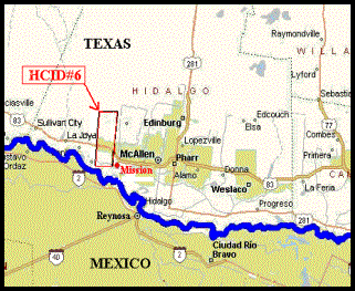
2. Project Location
Hidalgo County Irrigation District No. 6
(HCID#6) was created in February 1927, and its infrastructure and service area
are located adjacent to the US-Mexico Border along the western part of Hidalgo
County. The District boundaries extend west of the City of Mission, Texas and northward
about 12.5 miles from U.S. Highway 281. HCID#6 serves
an area covering approximately 18,900 acres. The Rio Grande River is the
only source of water for the District, providing
irrigation and water supply functions to 35.8 square miles of Hidalgo County. A
general location map of the District is shown below.
3. Project
Description and Work Tasks
The District serves
about 2,219 irrigation accounts with a reported 75% conveyance efficiency. The
Districts conveyance system also
provides raw water to the La Joya Water Supply Corporation, the La Frontera
Power Generation Plant, Bates Electric Power Generation Plant and the U.S.
Department of Agriculture at Moore Field. The District holds a State of Texas Certificate of Adjudication
(No. 23-828), which authorizes the diversion of 5,816 acre-feet of Rio Grande
water per annum for multi-use and 34,913 acre-feet of Rio Grande water for
Class "A" irrigation. Between the years 1986
and 1998, the average amount of water diverted by the District for irrigation
was 18,575 acre-feet; the lowest annual diversion being 10,133 acre-feet and
the highest annual diversion being 30,599 acre-feet during that timeframe.
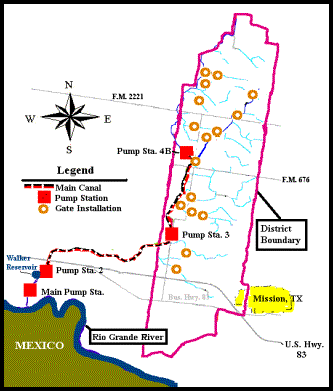
The District pumps water northward from its main pump station (Pump
Station 1), located 3,200 feet north of the Rio Grande on an artificial inlet
of the river. The District also maintains three re-lift stations on its main
canals: Pump Stations 2, 3 and 4B. A 60-acre regulating reservoir functions off
line between Pump Stations 1 and 2 to the east of the main canal. The reservoir
is used as a buffer to absorb changes in daily user consumption. Water flow
into and out of the regulating reservoir is controlled by means of a radial
gate located at the southwest corner of the reservoir. Walker Lake is a
116-acre area west of the main canal facing the current regulating reservoir.
The area was formerly used as a regulating reservoir, but was decommissioned in
2001 due to its large surface area relative to its storage capacity, which
resulted in excessive evaporation losses. At present the area is dry. The
District water supply system consists of approximately 45 miles of lined
canals, 72 miles of pipelines and 0.5 miles of unlined canal. The lined canals
are decades old and are quite deteriorated in some reaches.
The proposed project consists of four components; canal lining replacement, slide-gate replacement, expansion of the Districts regulating reservoir and installation of a telemetry system. The estimated construction completion period is projected to be 2 years from approval of funding. The total estimated water savings from the three components is 3,130 acre-feet.
1)
Canal Lining Renovation: This component includes
the renovation of the existing lining of approximately 9 miles of the
Districts main canal between Re-lift Pump Station No. 2 and Re-lift Pump
Station No. 4B. The canal consists of
approximately 30,500 feet of canal (5.8 miles) with a top width of 24 feet, and
17,100 feet of canal (3.2 miles) with a top width of 15 feet. The current
concrete lining was installed in 1930 and is significantly deteriorated in some
segments. The canal is proposed to be re-lined with a rubber liner to save water by eliminating seepage and their
associated pumping requirements and costs. The water savings will permit the
flow rate of water delivered to individuals to be increased or allow for a
greater number of fields to be simultaneously irrigated. The estimated annual
savings of water for this project component is 1,732 acre-feet, with an
estimated construction cost of $1,327,260.
2) Radial
Gate Bay Installation: This component includes replacement of 17 existing
deteriorated slide-gate structures on the northern section of the main canal
and major laterals with
radial gate bays. Water savings
will be obtained from the improved ability to avoid spills that result from
inadvertently over-charging the canal system, as well as from preventing leaks
from gate structures. The estimated annual savings from the replacement of the
slide-gates structures is 491 acre-feet, with an estimated construction cost of
$252,150.
3) Canal
Regulation: This component includes expansion of the storage reservoir
south of Re-lift Pump Station No. 2 and installation of instrumentation for
remote reporting of water surface levels in storage reservoirs and adjacent to
the three re-lift pump stations. The District has not used Walker reservoir for
some years due to its existing large surface area relative to its storage
capacity, so the plan is to re-establish Walker Reservoir as a component of the
Districts water management system. The
capacity of the reservoir is proposed to be increased by 200 acre-feet. The
increased storage capacity will provide a means for storing excess water when
available and utilizing the stored water when needed. The reservoir,
along with the three re-lift pump stations, will be provided with telemetry
instrumentation to control and report water levels upstream and downstream of
the pumps. The real-time data from the sensors will significantly improve the
District managements ability to detect and prevent water over-charging of the
canal the system, thereby reducing the incidence of spills. the annual
estimated savings of water from this component is 907 acre-feet, with an
estimated construction cost of $876,000.
A District layout, shown below, identifies the location of the project components.
4. Conformance with International Treaties and Agreements
The International Boundary and Water Commission (IBWC) is an independent bi-national public organization that ensures implementation of the 1944 Water Treaty between the United States and Mexico related to water and boundary issues. The HCID#6 project does not violate the allocation of water rights. The District will continue to meet all state surface water diversions from the Rio Grande in accordance with the agreements in place and the restrictions of the Treaty.
The Texas Commission of Environmental
Quality (TCEQ) and the International Boundary and Water Commission (IBWC) are
the authorities for allocation of water to the District. The 1944 Water Treaty between the United
States and Mexico applies. The District is organized under Article XVI, Section
59 of the Texas Constitution and operates under the provisions of Chapters 49
and 58 of the Texas Water Code. HCID#6 diverts water from the Rio Grande River
in accordance with a Permit issued by TCEQ.
TCEQs Rio Grande Watermaster Office in Harlingen is responsible for
allocating, monitoring, and controlling the use of surface water by the
District in coordination with IBWC. The State Watermaster also cooperates with
IBWC and its Mexican counterpart to monitor U.S. and Mexican compliance with
the U.S.-Mexico Treaty of 1944. There is no reported non-compliance by HCID#6
under the TCEQ permit.
Human Health and Environmental
1. Human Health and Environmental Need
The proposed project activities address one of the most pressing problems facing the Lower Rio Grande Valley of Texas, i.e., water shortages due to drought over the last seven years and an increasing demand due to population growth. Water conservation reduces the impact of drought conditions and makes available additional water resources that would otherwise be lost to meet both domestic and agriculture demands. The future health, social and economic well being of the population in the Rio Grande Valley will be dependent on conservation and maximizing beneficial use of available water to meet domestic and agricultural needs. The project addresses the critical water shortages by reducing water losses and providing for more efficient delivery of water, thus enhancing availability of water both domestic and agriculture use.
2. Environmental Assessment
Axiom-Blair Engineering completed an
Environmental Summary (ES) for the project. Preparation of the ES information
from a wide variety of sources including the TCEQ, the U.S. Census Bureau, the
U.S. Fish and Wildlife Service, the National Park Service, the Texas Historical
Commission, the National Weather Service, the U.S. Soil Conservation Service,
the U.S. Department of the Interior, the Texas Department of Transportation and
others. Additional information was
collected through visual field reconnaissance and interviews of locally
knowledgeable individuals. The
information collected is sufficient to support the following conclusions:
·
The
proposed project is necessary and will help meet the need for water and energy
conservation in the Lower Rio Grande Valley.
·
No short or
long-term detrimental socioeconomic effects are expected as a result of the
project. Socioeconomic impacts are
expected to be wholly positive.
·
No short or
long-term wildlife habitat disturbances are anticipated.
·
No
significant, long-term air, water or vegetative impacts are anticipated.
·
No cultural
resources will be impacted as a result of the proposed project.
·
From a
regional perspective, this Water
Conservation Improvement Project is expected to have a positive impact from
environmental and socio-economic perspectives, and no impact on
cultural-historical resources.
Preparation of ES utilized information for a wide variety of sources including the TCEQ, the U.S. Census Bureau, the U.S. Fish and Wildlife Service, the Texas Parks and Wildlife Department, the Texas Historical Commission, the National Weather Service, the U.S. Soil Conservation Service, the Texas Department of Transportation and on-site field reconnaissance.
The ES was submitted
to the Texas Parks and
Wildlife Department, Texas Historical Commission, U.S. Army Corps of Engineers
and the US Fish & Wildlife Agency for review. The U.S.
Army Corps of Engineers has determined that since the project sites do not
contain any areas subject to Section 10 of the Rivers and Harbors Act or
Section 404 of the Clean Water Act, a Department of the Army permit is not
required. The Texas Historical Commission reviewed the project under Section
106 of the National Historic Preservation Act of 1966 and the Antiquities Code
of Texas and determined that the project should have no effect on historic
properties. No further review is necessary from the Texas Historical
Commission. A written response is pending from the U.S. Fish and Wildlife
Service and the Texas Parks and Wildlife Department but no objections or issues
are expected.
Regardless of these jurisdictional determinations, it
is the Districts goal to protect the environment and its inhabitants. The
construction drawings include specifications requiring the contractor to
protect existing waterways, vegetation and wildlife from unnecessary
disruptions during construction. In addition, the District will file the
required Notice of Intent with the Texas Commission on Environmental Quality
(TCEQ) and prepare a Storm Water Pollution Prevention Plan before construction.
The construction of the proposed water conservation
measures will have an overall sustained positive environmental impact,
enhancing the prospects for continued economic growth of the region, as well as
the improved health and social well being of the regions growing population.
3. Compliance with Environmental
and Cultural Resource Laws and Regulations
The environmental review of the project and the proposed mitigation measures comply with all environmental and cultural resource laws and regulations. All required permit conditions necessary for the construction or operation of the proposed project will be acquired and complied with. The District has the required water rights and is fully compliant with the terms of its water use permit.
1) Appropriate Technology
The project plans were prepared and completed by
Axiom-Blair Engineering with State Energy Conservation Funds (SECO) provided to
the District by the Texas Water Development Board (TWDB). The activities are designed
to address the 2001 Adopted Region M Water Plan which calls for conservation
measures to offset the deficits, and in response to the enduring drought that has affected the lower Rio Grande Valley
over the past several years. The drought and the projected decrease in
irrigation water supply has required the District to place a greater emphasis
on water conservation to ensure the delivery of water to the customers they
serve.
The analyses for thee design of the three project components are described below.
1) Canal lining renovation: Four potential project alternatives were considered for the repair of the deteriorating concrete lined canal segments. Alternatives include the following:
· Replace the existing canal with concrete.
· Line the existing canal with a polyurethane liner.
· Line the existing canal with EPDM (ethylene propylene diene terpolymer) rubber liner.
· No-build alternative
Preliminary cost estimates indicated that replacing the existing concrete was 100 to 200 percent more expensive than lining the canal with a polyurethane liner or EPDM rubber. Concrete lining is susceptible to cracking and separating caused by expansion and contraction of the soil as well as heat expansion of the concrete itself, resulting in the problems the District is currently experiencing. No benefits were found to justify the additional cost and future problems of replacing the existing concrete lining. Replacing the existing canal with concrete was therefore eliminated as a viable alternative.
Both lining the canal with a polyurethane liner and EPDM rubber liner have the positive benefit of virtually eliminating seepage and low maintenance costs. The polyurethane liner has certain advantages, such as the ability to bond to the concrete and mold itself to irregular and vertical channel sections. The liner has a self-adhesive property that eliminates the need for patching the seams. But typical installation costs are $1.43 per square foot. Also, polyurethane liners are a relatively new technology, and while tests in the Lower Rio Grande region have shown promise, certain problems remain to be resolved, as described by the Bureau of Reclamation in their November, 2002 report R-02-03: It is difficult to maintain quality control, particularly in the presence of water, the heavy lining machine requires a large access area, and seams are weak.
EPDM
rubber liners have been in use for more than 40 years and represent a proven
alternative, having demonstrated long-term durability, puncture resistance, flexibility
and ease of installation. The unit installation cost for EPDM rubber liner is
about $0.40 per square foot, making it the preferred alternative for this
application. This alternative to fully relining the canal with EPDM rubber will
be selected for sections where the lining is rated very good to excellent (according to the rating system used in the
December, 2000 study by Texas A&M University entitled Potential Water
Savings in Irrigated Agriculture for the Rio Grande Planning Region (Region M).
Taking
into consideration the ongoing drought and the Districts commitment to water
and energy savings, the no-build alternative was eliminated from consideration.
However, in certain sections of the Main Canal between Re-lift Pump Station No.
3 and Re-lift Pump Station No. 4B, the existing concrete canal is in quite good
condition and may only require spot repairs using fiberglass-reinforced
shotcrete. This alternative will be selected for sections where the lining is
rated very good to excellent ((according
to the rating system used in the Texas A&M study cited above).
2) Slide-gate
replacement: This component involves the replacement of
seventeen existing slide-gate structures on the main canal and major laterals
with radial gate bays. Radial gate check structures have the advantage of being
more responsive and reliable and less prone to leaks than slide gate
structures. A radial gate consists of a curved gate leaf, rubber seals, support
arms, seal rubbing embedments and embedded pivot points. The gate leaf is of a
welded construction varying in width and height as required by the size of the
opening. Embedded rubbing seats are mounted flush with the wall to provide a
smooth flat surface for the seals to slide on as the gate opens and closes.
Water pressure applied against the curved gate leaf is transmitted through the
support arms into the pivot points that are embedded in the concrete wall.
Since the gate leaf is curved, the water also applies a pressure upward,
thereby lowering the lifting force required. A smaller hoist is therefore
necessary as compared to other types of gates.
The
replacement of leaky gates will allow the District Manager to control the
status of water storage in the main canal and reliably make adjustments as
required. Water savings will be obtained from the improved ability to avoid
spills that result from inadvertently overcharging the canal system, as well as
from the prevention of leaks from deteriorated slide-gate check structures.
3) Canal
regulation: The main
component of the regulation project is the reestablishment of the Walker
Reservoir area as a component of the Districts water management system. Due to
its large surface area relative to its storage capacity, the District has not
utilized the Walker Reservoir for some years. Material will be excavated from
the former wetted area and placed in levees on site. Two radial gates will be
constructed adjacent to the Main Canal west of the existing reservoir to
control water intake and outlet from the Walker Reservoir. An additional
component of the regulation project is the installation of a telemetry system
to report water levels at both reservoir locations to a central control system
to be located in the District office. The three re-lift pump stations will also
be provided with telemetry systems to report water levels upstream and
downstream of the pumps. The real-time data from the sensors will significantly
improve management of the system.
Each of the measurement devices on the
individual sites will be connected to a single telemetry system to allow the
District to periodically, and on demand, poll for data from the field devices
(remote telemetry unit (RTU)), and process the data into a central database
(base computer). A base system will be located at the District Headquarters and
will consist of a base computer, which will hold the central database to store
and convert all of the data from the RTUs, and an antenna to receive from the
remote telemetry information. The base computer will be equipped with software
that will display current, last 24 hours and monthly water and flow level data
of any or all of the RTUs. A remote telemetry system will be installed at each
of the flow measurement sites. Each system will consist of the following:
a)
Remote
Telemetry Unit (RTU)
b)
2. Radio and
RF Modem
c)
AC/DC Linear
Power Supply
These items will be mounted inside a steel
NEMA 12 enclosure on a panel with room for a storage battery to be placed on
the bottom of the enclosure. A radio antenna will be mounted on a 20-foot antenna
mast for transmitting and receiving data from the Base System. The telemetry
system enclosure will be installed in a steel vandal box and wired to the
existing power source. Once the telemetry system enclosures are mounted, the
RTU will be wired to the metering devices and antenna.
2. Operation
and Maintenance Plan
The operation and
maintenance requirements for the improvements to the facilities are basically
the same as already performed on the existing pipelines and canals of the
system. The existing staff is
considered sufficiently capable and experienced to undertake required
maintenance of the new pipeline and canal.
Equipment suppliers will be required to provide training on the
operation and maintenance of equipment, including provision of O&M manuals.
3. Compliance
with Applicable Design Standards and Regulations
The design and
construction requirements will adhere to USBOR requirements under the
Guidelines for Preparing and Reviewing Proposals for Water Conservation and
Improvement Projects under Public Law 106-576. USBOR design standards and
criteria were applied and USBOR quality control procedures will be applied
during construction.
Financial Feasibility and Project Management
1. Financial
Feasibility
Axiom-Blair Engineering prepared an
analysis of project and the Districts financial condition to provide matching
funds for proposed funding structure of the project and the operation and
maintenance of the system. The estimated project costs based on the design
information are as follows:
PROJECT COSTS
|
ITEM |
FUNDING
SOURCE |
TOTAL |
|
Planning |
HCID#6
& SECO |
$70,060 |
|
Design/Construction
Contracting |
HCID#6
& SECO |
$255,000 |
|
Construction
Administration |
HCID#6 |
$219,530 |
|
Construction
Cost |
HCID#6
& NADB |
$2,455,410 |
|
TOTALS |
|
$3,000,000 |
Cost in U.S.
Dollars. August 2003
The funding sources for the project are
summarized in the table below. Based on
the WCIF Guidelines, the WCIF grant may support 50% of the project costs up to,
or a maximum of, $4,000,000. The
funding sources for the projects are as follows:
FINANCIAL STRUCTURE FOR THE PROJECT
|
Source |
Type |
Amount USD |
% Project Cost |
|
NADB
|
WCIF-Grant |
$1,500,000 |
50% |
|
State
of Texas |
SECO
Grant |
$153,060 |
5% |
|
HCID#6 |
Cash
& In-Kind |
$1,346,940 |
45% |
|
TOTAL |
|
$3,000,000 |
100% |
2. Rate
Model
The table below
summarizes the existing fee and assessment structure.
Existing Assessment Fee Structure
|
Fees |
Per Acre |
|
Annual O&M Tax |
$19.00 |
|
Water Assessment (per acre irrigated) |
$26.00 |
In addition to the above, the District
earns significant income from water allocation sales; revenues earned from the
lease of water rights. The proposed projects and funding source structures do
not require an adjustment to the current Fee and Assessment Structure
implemented by the District.
3. Project
Management
The project will be managed and implemented by HCID#6 over a two-year construction period (2004-2005), with contracted engineering services for the necessary technical and management support for project administration. The telemetry system is expected to be contracted, and the rest of the work is expected to be undertaken by District crews with District equipment (force-account work). The District has managed construction activities of similar magnitude. The District owns numerous pieces of heavy construction equipment such as track excavators, backhoes, boom trucks, concrete pumps, and dump trucks and has a long track record of constructing irrigation water conveyance systems. The District can operate in a self-sufficient manner, supporting itself through user fees, but is expected to apply for future potential USBOR grant resources for the project. The existing organizational structure which has been provided is considered sufficient and the project will not require additional District staffing, except for additional labor only for the proposed force-account construction.
Community Participation
1. Comprehensive Public Participation Plan
The Public Participation Plan submitted by HCID#6 and the Project Steering Committee was approved on April 30, 2003.
2. Steering Committee
The Steering Committee was composed of Thomas Thompson, President, Board of Directors, HCID#6; Norberto Salinas, Mayor, City of Mission; Joe Guerra, Manager, AEP Bates Power Plant; and Cornelio Morales, Manager, HDIC#6. As a result of the effectiveness of this steering committee, the water conservation efforts proposed though these projects was well received by the water users in the District.
3. Local Organizations
Presentations were made by Cornelio Morales, District General Manager, to USDA-Moore Air Field, La Joya Real Estate, La Joya Water Supply and Frontera Power Plant. Joe Guerra made a presentation to American Electric Power Plant and Norberto Salinas provided information to the city of Mission. Letters of support have been provided by USDA-Moore Air Field, La Joya Real Estate, La Joya Water Supply Corporation and American Electric Power.
4.
Public Information
Project Information such as the Project Proposal, Step I Application and draft Project Strategic Plan were available for review at the HCID#6 office. A fact sheet was developed and distributed to District water users and was made available at public meetings. Fact sheets were also available for walk-in customers at the HCID#6 office and were posted in local businesses. Notices of public meetings were published in the McAllen Monitor.
5. Public
Meetings
Three public meetings were held in 2003. The first meeting took place on June 2, the second meeting took place on June 3 and the third meeting took place on August 21, 2003. Surveys collected at the end of each meeting indicated that the information received regarding the project was understood and there was no documented opposition to the project.
Sustainable Development
1. Definition
and Principles
Sustainable Development Criteria is defined as conservation oriented social and economic protection and sustainable use of resources, while addressing both current and future needs, and present and future impacts of human actions. This definition is based on the Rio de Janeiro Declaration on Environment and Development, which states that development should meet the needs of the present without compromising the ability of future generations to meet their needs.
All of the proposed project components will comply with the definitions and principals of Sustainable Development in that they positively impact the area and sustainable life of the areas residents through the conservation of water. Water conservation is critical to quality and life and economic growth in the Rio Grande Valley. The Canal Rehabilitation, Radial Gate Bay Installation, and the Canal Regulation projects will help to reduce the seepage of valuable water. In addition to water savings, the District will experience energy savings through a more efficient delivery system.
2. Institutional
and Human Capacity Building
The Rio Grande Regional Water Plan, in support for the implementation of agricultural water conservation strategies, includes the following actions for reduction of irrigation shortages:
· Expanded technical assistance should be available from local, state and federal sources to assist irrigation Districts with more detailed systematic evaluations of District facilities and management policies to identify cost effective water efficiency improvements.
· The State of Texas and the federal government should assist with the financing of irrigation water improvements through the provision of low interest loans and grants.
Accordingly, due to the limited financial capacity if irrigation Districts, the State of Texas through the State Energy Conservation Office (SECO) and the Texas Water Development Board (TWDB) provided financial assistance to the District for the preparation of the project plan and the necessary documentation required to meet the federally appropriated funds.
The project plans for the proposed projects were completed under the Lower Rio Grande Valley Water Resources Conservation and Improvement Act of 2000 (Act), Public Law 106-576. The Act also provides limited funding availability for engineering work, infrastructure construction and improvements. An amendment to the Act (H.R. 2990/S.1577) authorized funds provided by the for conservation projects, including the Canal Rehabilitation, Radial Gate Bay Installation, and the Canal Regulation projects.
The project plans for the four projects were prepared in accordance with the Guidelines for Preparing and Reviewing Proposals for Water Conservation and Improvement Projects, associated with the Act. Public Law 106-576. The project plan was prepared in partial fulfillment of between the TWDB and HCID#6.
The District entered into a contract with the TWDB, whereby the TWDB will reimburse the District, with grant funds, for the cost of preparing the project plan, project report, plans and specifications and monitoring reports for the proposed
project.
The North American Development Bank (NADB) Water Conservation Infrastructure Fund (WCIF) will complement, with grant funds, the capital investments required by the District for construction of these projects. The use of WCIF grant funds allows the District to fully finance its infrastructure in order to reduce water conveyance losses.
The projects will be managed by the District and will be constructed and operated in conformance with Federal, State and NADB requirements. The process for the development of the projects has followed a planning and public participation process that developed alternatives and associated costs, solicited public input, established priorities based on the input of the stakeholders and proceeded according to the priorities established in the planning process.
The HCID#6 has an annual operating budget of approximately $2.0 million. The District has funds and staff capable of meeting the obligations of the District for the proposed projects.
Contractors will be selected by competitive bidding pursuant to the requirements of Texas water Code Section 49.273.
Since, 1985, the District has systematically replaced their existing main canal pumps at lift stations 2, 3 and 4 with modern vertical shaft mixed flow pumps. These new pumps are approximately 5% more efficient that older horizontal shaft pumps.
There is a 300 acre-foot regulating reservoir located between Pump Station 1 on the Rio Grande and Re-lift Station No. 2 on the Districts Main Canal. The District has not used the reservoir for some years due to its existing large surface area relative to its storage capacity The regulating reservoir allows the District to storage no charge water that would otherwise be lost downstream in the Rio Grande.
In 1989 the District developed a computer database that is used to account and manage water allocation, taxes, and water use invoices. The database contains flow-metering records for all turnouts in the District, and the amount of irrigable land owned by each landowner within the District.
A monitoring program will be established for a two-year period to evaluate and quantify the actual water and energy savings following construction of the projects. This program will serve as a systematic outline for documenting the successes of the project. The program will include, at a minimum, sufficient information to allow for completion of the following tasks:
· Designation of a construction inspector not affiliated with the primary construction contractor to inspect and administer construction quality control documentation for the proposed projects.
· Hydrostatic seepage tests of the installed canal liners by the District or Texas A&M. Hydrostatic leakage tests of all structures.
· Inspection of the lined canal reaches one and two years after the initial installation. Inspection should check structural integrity, cracking and leakage. Photographs should be taken of the inspected portions and a letter from the project engineer should be prepared summarizing the condition of the liner and if the contractor pursuant to the construction contract documents warrants any repairs.
· Preparation of an annual report containing the monthly reports and any other data collected.
· The electrical use per acre-foot of water pumped will be determined on a monthly basis and submitted annually. The annual report will include the historic electrical costs per acre-foot for comparison.
· The amount of water pumped will be measured and compared with the water delivered on a monthly basis and submitted annually. The annual report will include historic water pumped and water delivered volumes for comparison.
3. Conformance
with Applicable Local and Regional Conservation and Development Plans
The proposed project complies with all local and regional conservation and development plans. In particular, the project complies with the Rio Grande Regional Water Plan, which recommends agricultural water conservation and on-farm water use efficiency in order to reduce irrigation shortages.
The project Report has been prepared in accordance with the Guidelines for Preparing and Reviewing Proposals for Water Conservation and Improvement Projects Under Public Law 106-576 issued by the U.S. Department of Interior, Bureau of Reclamation, June 2001.
The project is in conformance with local conservation efforts already developed by the District and served communities. Conservation of water is stresses and penalties are assessed for overuse of water. The municipalities served by the District have their own water conservation plans. A water allocation plan (Drought Contingency Plan), goes into effect for irrigation when the irrigation water account storage balance amounts to a maximum of three irrigations per acre. This program remains in effect until the water is restored to the Districts irrigation account.
4. Natural
Resources Conservation
The proposed project was developed with the intent of conserving water. The Districts authorized irrigation water rights are 34,913 acre-feet per year. However, these water rights are on an as available basis and the actual water available to the District may vary from year-to-year.
In addition to the irrigation water right, the District holds authorized multi-use water rights for 5,816 acre-feet per year. The District contracts to deliver raw water to the La Joya Water Supply Corporation and the following industrial entities:
· American Electric Power Bates Power Plant
· Frontera Power Generation Plant
· USDA @ Moore Air Field
According to Axiom-Blair Engineerings analysis of the project in accordance with the USBOR Guidelines for Preparing and Reviewing Proposals for Water Conservation and Improvement Projects Under Public Law 106-576, Lower Rio Grande Valley Water Resources Conservation and Improvement Act of 2000, implementation of the project will allow an estimated water savings of 3,130 acre-feet per year, and an energy savings of 255,676 KWH per year on an average annual basis, as shown in the following table.
|
Project Component |
Project Description |
Annual Water Savings (Acre-feet) |
Annual Energy Savings (KWH) |
|
Canal Lining |
Repair and Impervious Lining of Portions of Main Canal for transport of irrigation and municipal water |
1,732 |
171,110 |
|
Canal Gate Replacement |
Replacement of Canal and Lateral water Level Control Structures |
491 |
44,783 |
|
Canal Regulation and Telemetry |
Renovation of Regulating Reservoir and Installation of Water Level and Flow Measurement Telemetry |
907 |
39,784 |
|
Total Annual Savings |
3,130 |
255,676 |
|
Water conservation by the District has become
increasingly important due to an enduring drought that has affected the lower
Rio Grande Valley over the past several years. The drought and the projected
decrease in irrigation water supply has required the District to place a
greater emphasis on water conservation to ensure the delivery of water to the
customers they serve.
The lining of canals and installation of telemetry to improve water management will increase the efficiency of the District and use of water. More controlled water delivery will reduce losses and will improve delivery at the farm level. The proposed improvements will also allow the District to reduce the impact of water shortages on agriculture versus water for municipal use due to continued growth in the Cities of Lyford, Raymondville and the North Alamo Water Supply Corporation as well as other small rural communities. The Cities and the District will be able to enhance sustainable growth within available resources.
5. Community Development
The benefit obtained by modernization of the irrigation facilities may directly impact agricultural production and may result in increased income and an improved quality of life for end users. Making residents active participants in development of their community may also enhance economic activity. An improved quality of life for the residents may also have a favorable impact on the development of health and education in the area.
Available Documents
§
Axiom-Blair Engineering, Project Plan for the
Hidalgo County Irrigation District No. 6
Water Conservation Improvements Project July 2003.
§ Axiom-Blair Engineering, Draft Project Report for the Hidalgo County Irrigation District No. 6 Water Conservation Improvements Project, August 2003.
§ Axiom-Blair Engineering, Draft Financial Feasibility Report, Hidalgo County Irrigation District No. 6 Water Conservation Project August 2003.
§ Axiom-Blair Engineering, Environmental Summary for the Hidalgo County Irrigation District No. 6 Water Conservation Improvements Project, June 2003.
§ Axiom-Blair Engineering, Draft Sustainable Development Report for the Hidalgo County Irrigation District No. 6 Water Conservation Improvements Project, August 2003.
§ Fipps, Guy, Potential Water Savings in Irrigated Agriculture for the Rio Grande Planning Region (Region M) Final Report, Texas Agricultural Extension Service, Texas Agricultural Experiment Station and Texas A&M University, December 22, 2000.
§ Texas Water Development Board, 2001 Adopted Rio Grande Regional Water Plan (Region M), January 2001.
§ United States Department of the Interior Bureau of Reclamation, Guidelines for Preparing and Reviewing Proposals for Water Conservation and Improvement Projects Under Public Law 106-576, Lower Rio Grande Valley Water Resources Conservation and Improvement Act of 2000, June 2001.