Border
Environment Cooperation Commission
Hidalgo County
Irrigation District No. 2 (San Juan)
Wisconsin Canal and
Lateral A
Water Conservation Improvement
Projects
General
Criteria
1.
Project Type
This document includes two
distinct projects proposed by Hidalgo County Irrigation District (HCID) No. 2.
The two projects fall under the Border Environment Cooperation Commission (BECC)
priority area of water conservation. The proposed projects are to implement
priority improvements to the conveyance system of the District to reduce
evaporation and seepage losses and operation and maintenance costs. The
projects include the upgrading of two of primary canals, the 2-mile Wisconsin
Canal and the 7.26-mile Lateral A canal.
2. Project Location
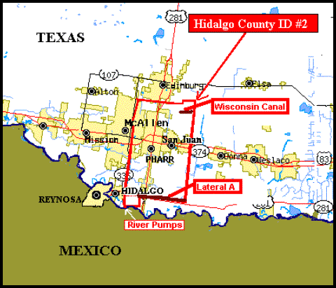
HCID No. 2, originally established in 1928, covers 64,828.12 acres located in the central part of Hidalgo County in the lower Rio Grande Valley of Texas. The southwest corner of the District borders the Rio Grande River near the City of Hidalgo and the District extends from State Hwy. 281 north to the vicinity of Edinburg, Texas. The District pumps water directly from the Rio Grande into a settling basin (reservoir) via a gravity canal, and then into a conveyance system of pipelines and canals.
The District delivers water to 47,000 acres of irrigable land under 4,000 water accounts, and also delivers raw water to five (5) municipalities and one water supply corporation - Alamo, McAllen, Pharr, San Juan, and Edinburg and the North Alamo Water Supply Corporation. The District has an authorized irrigation water right of 137,675 acre-feet of water per year (168.8 million cubic meters of water per year); the fourth largest water right of the 28 irrigation and water supply districts in the Lower Rio Grande Valley. In addition, the District holds domestic, municipal and industrial water rights totaling 12,732 acre-feet per year. Below is a location map of the District.
3.
Project
Description and Work Tasks
The District obtains water directly from the Rio
Grande River near the vicinity of Hidalgo, Texas, with a pumping plant
consisting of ten-65cfs electric pumps. The District pumps are located 3,200
feet upstream of an overflow dam (weir) on the Rio Grande River which raises
the river level about one foot at the pump intake point. The water used by the
District is released by IBWC from the upstream Falcon Reservoir. The District
diversion pumps discharge into a main canal flowing via gravity into a 1,800
acre-foot (586.5 million gallon or 2.2 million cubic meter) unlined settling
basin or reservoir near the pump station. Water
is then gravity fed from the reservoir into the conveyance system consisting of
71 miles of canals (24.3 miles lined)
and 230.8 miles of pipelines. The southern part of the conveyance system is
gravity fed from the reservoir, and the northern part is reached with a re-lift
pump station and gravity flow thereafter.
Irrigation is undertaken by 4,000 water accounts
for farms ranging from 200 acres to 2,500 acres. Irrigation occurs using furrow
irrigation delivered by polyethylene field distribution systems or traditional
open laterals. Farm turnouts supply water either to open ditches or gated
pipes. A typical turnout delivers water to about 40 acres and the landowner
receives about 6 inches of flood irrigation water per acre of irrigation. Each
irrigation takes 3-4 days, and deliveries are not metered. There is some use of
drip/micro-jet systems in citrus fields, which account for about 3.5% of the
total 47,000 acres of irrigated acreage.
Water is delivered to the municipalities via canals to their respective
reservoirs and treatment plants. In 2002 the District had an overall estimated conveyance
efficiency of 80%, thus based on the average annual diversion of water by the
district of 55,880 acre-feet from 1998 through 2002, the loss due to
evaporation and seepage was about 11,176 acre-feet per year.
The proposed projects include the upgrading of two of
primary District canals, the Wisconsin Canal and Lateral A, to eliminate water
loss form evaporation and seepage and to reduce maintenance requirements. These two projects are priorities among
overall repair and upgrading needs of the District.
Wisconsin Canal
The existing 2-mile long Wisconsin Canal is concrete-lined;
constructed in 1911 and renovated in 1986. The renovation consisted of raising
the depth of the canal from 1 to 1.5 feet. The canal has a parabolic section varying
from 12 feet at the 16 feet upstream to 12 feet at the downstream end, with a
depth running from 6.75 feet to 5 feet. The canal is located just north of
Wisconsin Road in the northeast part of the District. The canal serves 1,872
acres of land and is supplied by a 48-inch reinforced concrete gravity pressure
main from the Districts reservoir. The demand for this area is 23.8 cfs. The
existing lining of the Wisconsin canal was originally constructed without any
barrier lining and is now severely cracked.
Seepage will eventually result in failure of the canal. Replacement of
the canal with a 48-inch reinforced concrete pipe is proposed to eliminate
losses in this primary section of the system and reduce maintenance costs. The
estimated savings of water with replacement of the canal with a pipeline is 977
acre-feet per year, including savings from evaporation, seepage and improved
metering. This savings is based on a ponding tests and economic and
conservation analyses completed by the Texas Water Resources Institute, Texas
A&M University.
The final design for the project is planned to be completed
by July 2003, with competitive bidding and award of a contract for construction
by August 2003 and construction completion by mid-January 2004 (5.5 month construction
period).
Lateral A
The existing Lateral A canal is a concrete lined canal
running east along the south boundary of the district form 7.26 miles starting
at the Districts reservoir. The canal was constructed in 1911 and renovated in
1986. The renovations consisted of raising the depth from 18 inches at the
reservoir to 6 inches at the downstream end. The canal has a parabolic section
with a top width varying from 18 feet at the reservoir to 12 feet at the
downstream end, with a depth running from about 4.5 feet to 2.5 feet. The canal
serves 6,640 acres of land with an estimated demand of 82 fps. The existing
lining of Lateral A is severely cracked with the potential for failure due to
continued deterioration and seepage. Lateral A is proposed to be lined with a
geomembrane covered with a 3-inch shotcrete cover, and field turnouts are
proposed to be reconstructed so that portable meters can be used to set flow
rates to fields. With these improvements, the estimated reduction in seepage
and metering losses will be 2,542 acre-feet per year. This savings is based on a ponding tests and economic and
conservation analyses completed by the Texas Water Resources Institute, Texas
A&M University.
The final design for the project is planned to be completed
by September 2003, with competitive bidding and award of a contract for
construction by mid-October 2003 and construction completion by the end of
February 2004 (4.5 month construction period).
4.
Conformance with
International Treaties and Agreements
The
International Boundary and Water Commission (IBWC) is an independent
bi-national public organization that ensures implementation of the 1944 Water
Treaty between the United States and Mexico related to water and boundary
issues. The projects do not violate the allocation of water rights. The
District will continue to meet all state surface water diversions from the Rio
Grande in accordance with the agreements in place and the restrictions of the
Treaty.
The Texas Commission of Environmental
Quality (TCEQ) and the International Boundary and Water Commission (IBWC) are
the authorities for allocation of water to the District. The 1944 Water Treaty between the United
States and Mexico applies. HCID No. 2
diverts water from the Rio Grande River in accordance with a Permit issued by
TCEQ, governed by Chapters 49 and 58 of the Texas Water Code and Article XVI,
Section 59 of the Texas Constitution. TCEQs Rio Grande Watermaster Office in
Harlingen is responsible for allocating, monitoring, and controlling the use of
surface water by the District in coordination with IBWC. The State Watermaster
also cooperates with IBWC and its Mexican counterpart to monitor U.S. and
Mexican compliance with the U.S.-Mexico Treaty of 1944. There is no reported
non-compliance by HCID No. 2 under the TCEQ permit.
Human Health and Environmental
1. Human Health and Environmental Need
The proposed projects address one of the most pressing problems facing
the Lower Rio Grande Valley of Texas, i.e., water shortages due to drought over
the last seven years and an increasing demand due to population growth. Water
conservation reduces the impact of drought conditions and makes available
additional water resources that would otherwise be lost to meet both domestic
and agriculture demands. The future health, social and economic well being of
the population in the Rio Grande Valley will be dependent on conservation and
maximizing beneficial use of available water to meet domestic and agricultural
needs. The project addresses the critical water shortages by reducing water
losses and providing for more efficient delivery of water, thus enhancing
availability of water both domestic and agriculture use.
2. Environmental Assessment
In accordance with the Council of
Environmental Quality (CEQ) Regulations (Section 1508.4) under the National
Environmental Policy Act (NEPA) the U.S. Bureau of Reclamation (USBOR) has
adopted the procedure in compliance with CEQ (1507.3 [b]) to issue a
Categorical Exclusion after the evaluation of the possible environmental
effects that would occur with the implementation of the proposed projects. The required Categorical Exclusion Checklist
was completed and signed on May 23, 2003, whereby the USBOR determined that the
proposed actions do not individually or cumulatively have a significant effect
on the human environment and for which, therefore, neither an environmental
assessment (EA) nor an environmental Impact Statement (EIS) is required.
Mitigation measures identified in the
environmental review which will be required to be implemen2ted under the
project, are:
·
A mixture of grasses and forbs appropriate to address potential
erosion problems and long-term cover would be planted over disturbed areas.
·
Existing trees and woody vegetation would remain undisturbed if
possible. If not avoidable, stands of
native brush and woods would be surveyed for nesting migratory birds during the
nesting period of March through August, and then not be disturbed if any were
found.
·
All State and Federal permit conditions necessary for the
construction or operation of the proposed project would be acquired and
complied with.
Overall, the construction of the
proposed water conservation measures will have a sustained positive
environmental impact, enhancing the prospects for continued economic growth of
the region, as well as the improved health and social well being of the
regions growing population.
3. Compliance with Environmental
and Cultural Resource Laws and Regulations The USBOR environmental review of the
projects and the proposed mitigation measures comply with all environmental and
cultural resource laws and regulations.
The District has the required water rights and is fully compliant with
the terms of its water use permit.
Technical Feasibility
1.
Appropriate Technology
Project Plans for each project were completed in
accordance with USBOR guidelines, funded by the Texas Water Development Board
(TWDB) State Energy Conservation Office (SECO) funds. Various alternatives were
considered for the conveyance of water in the Wisconsin and Lateral A canals to
reduce water losses and reduce operation and maintenance costs. USBOR Design
Criteria were applied. The options considered for improvements under each
project included: 1) canal lining with a fluid-applied membrane; 2) concrete
lining; 3)
exposed geomembrane lining; 4) shotcrete with geomembrane underlining; and 5)
replacement with underground piping.
In February 2001, the firm of Siglar, Greenwood & Associates , Inc. completed an engineering report for the proposed improvements for the canals, including an analysis of the options. Based on this report, including more recent analyses contained in USBOR Project Reports for each project dated May 2003, the selected canal improvements are summarized below.
Wisconsin Canal
The 2-mile Wisconsin Canal is proposed to be replaced with a buried 48-inch reinforced concrete pipe running parallel and within the right-of-way of the existing canal based on the Siglar, Greenwood & Associates engineering report. Existing canal structures and concrete lining will be either buried or salvaged as appropriate. Farm turnouts will require replacement with the new pipeline and will be designed to accommodate the use of drop-in portable meters at a minimum 3 cfs. Gates/valves will be designed such that once flows are adjusted by the ditch rider, they can be locked in place for the duration of the delivery. With this method, only one or two flow meters will be required for each ditch rider rather than having a flow meter dedicated for each delivery point. A drain turnout will be required at the end of each lateral pipeline, and a surge structure will be required at the end of the new pipeline. Road crossings over the existing canal will be evaluated on a case-by-case basis for replacement or left in place. U.S Bureau of 3Reclamation standards and design criteria will be applied.
The proposed 2-mile pipeline will convey 24 cfs of water to serve an area of 1,872 acres. The estimated amortized annual water savings is 977 acre-feet per year, based on the Texas Water Resources Institute (Texas A&M University) Economic Methodology for South Texas Irrigation Projects, which was approved by the USBOR. The Texas Water Resources Institute economic study also estimated an amortized energy savings of 109,289 kwh/yr. at the main pumping plant and a relift pump station with completion of the proposed project.
Lateral A
The proposed improvements to the 7.26-mile Lateral A canal include the placement of a geomembrane underliner with a 3-inch shotcrete cover based on the USBOR Project Report of May 2003. The geomembrane provides the water barrier and the shotcrete protects the geomembrane, with an estimated 50-year life. The membrane will consist of a 15-mil (0.381 mm) geomembrane sandwiched between two layers of 6-oz. (170.1 gram) geotextile. The geomembrane will have thermal-bonded seams every 20 feet. The membrane is estimated to have a long-term seepage reduction effectiveness of 95%. This lining option is the most costly of the lining options at $2.60 installed cost per sq. ft., but it has the longest service life, the highest seepage reduction effectiveness and the lowest O&M costs of all other lining options. Other membrane options have estimated 20-year service lifes, a maximum 90% seepage reduction effectiveness and require more maintenance and repairs (perhaps twice as much) due to their exposure to the weather and potential for mechanical damage. Farm turnouts will be reconstructed so that portable meters can be used to set flow rates to fields. with characteristics similar to those proposed for the Wisconsin canal will be used, including the application of U.S. Bureau of Reclamation standards and design criteria.
Replacement of the canal with piping was considered but
was not selected due to the excessive construction cost, estimated at $9.1
million, coupled with the environmental 2impact of construction near a wildlife
area.
The canal serves an area of 6,640 acres. The estimated amortized annual water savings is 2,542 acre-feet, based on the Texas Water Resources Institute Economic Methodology for South Texas Irrigation Projects, which was approved for by the USBOR. The Texas Water Resources Institute economic study also estimated an amortized energy savings of 161,705 kwh/yr. at the main pumping plant with completion of the proposed project.
2. Operation
and Maintenance Plan
The
operation and maintenance requirements for the improvements to the facilities
are basically the same as already performed on the existing pipelines and
canals of the system. The existing
staff are considered sufficiently capable and experienced to undertake required
2maintenance of the new pipeline and canal.
The meter supplier will be required to provide training on the operation
and maintenance of meters when delivered.
3.
Compliance
with Applicable Design Standards and Regulations
The design and construction requirements adhere
to USBR requirements under the Guidelines for Preparing and Reviewing
Proposals for Water Conservation and Improvement Projects under Public Law
106-576 as per the memorandum of agreement between the HCID No. 1 and the
USBR. USBR design standards and criteria were applied and USBR quality control
procedures will be applied during construction.
Financial Feasibility
and Project Management
1.
Financial
Feasibility
BECC
reviewed information concerning the projects and the Districts financial
condition to obtain sufficient support of the Districts capability to sustain
the proposed funding structure of the projects and the on-going operation and
maintenance of the improvements. The estimated project costs for
the two projects based on preliminary design information are as follows:
Cost of the Project for the Wisconsin Canal
|
ITEM |
Funding
Source |
TOTAL |
|
Planning |
SECO/HCID#2 |
$
66,560 |
|
Design |
SECO/HCID#2 |
$
27,566 |
|
Construction |
WCIF/HCID#2 |
$1,580,300 |
|
TOTAL |
|
$
1,674,426 |
Cost in Dollars. June 2003
Cost of the Project for the Lateral A Canal
|
ITEM |
Funding
Source |
TOTAL |
|
Planning |
SECO/HCID#2 |
$
104,815 |
|
Design |
SECO/HCID#2 |
$
114,300 |
|
Construction |
WCIF/HCID#2 |
$
3,154,170 |
|
TOTAL |
|
$
3,373,285 |
Cost in Dollars. June 2003
The
funding sources for the project are summarized in the table below. Based on the WCIF 2Guidelines, the WCIF
grant may support 50% of the project costs up to or a maximum of $4,000,000. The funding sources for the projects are as
follows:
Financial Structure for the
Wisconsin Canal
|
Source |
Type |
Amount USD |
% Project
Cost |
|
NADB |
WCIF- Grant |
$
600,000 |
35.9% |
|
State of Texas |
SECO Grant |
$
94,126 |
5.6% |
|
HCID #2 |
Cash |
$
846,300 |
50.5% |
|
HCID #2 |
In-Kind |
$
134,000 |
8.0% |
|
TOTAL |
|
$
1,674,426 |
100.0% |
Financial Structure for the
Lateral A Canal
|
Source |
Type |
Amount USD |
% Project
Cost |
|
NADB |
WCIF- Grant |
$
586,383 |
17.4% |
|
State of Texas |
SECO Grant |
$
330,669 |
9.8% |
|
HCID #2 |
Cash |
$
2,423,233 |
71.8% |
|
HCID #2 |
In-Kind |
$
33,000 |
0.9% |
|
TOTAL |
|
$
3,373,285 |
100.0% |
The
BECC requested a third party review of the capability of the District for
supporting the initial investment and the sustainability of operations and
maintenance for the project. BECCs
financial consultant, Brown and Caldwell, rendered an opinion concluding that
the District does provide this capability without an adjustment to the current
Fee and Assessment Structure. This
capability includes the support of those project costs to be requested for
later reimbursement by the Bureau of Reclamation.
The
District has developed the project in accordance with requirements for funding
participation by the United States Bureau of Reclamation (USBOR). The District has submitted the project for
consideration by USBOR. Should the
USBOR funding become available, the District will request reimbursement for
approved cash expenditures.
2.
Rate
Model
The rate model for this type of Project Sponsor
is better described as a Fee and Assessment Structure. The District charges an annual operations
and maintenance assessment (tax) of $8.25 per irrigable acre. The tax is levied by October 1 of the prior
year. In addition, the District charges
a water assessment of $7.50 per acre per irrigation. The fee structure for Hidalgo County Irrigation District #2 has
not been adjusted during the historic five-year period. The table below summarizes the existing
structure.
Existing Assessment Fee Structure
|
Fees |
Per Acre |
|
Annual O&M Tax |
$8.25 |
|
Water Assessment (per acre irrigated) |
$7.50 |
The proposed projects and funding source structures do not require
an adjustment to the current Fee and Assessment Structure implemented by the
District.
3.
Project
Management
The project will be managed by Hidalgo County
Irrigation District #2. The District
has managed the construction of similar magnitude. The District will operate in a
self-sufficient manner, supporting itself through user fees. The project
will not require additional staffing.
Therefore, the existing organizational structure, which has been
provided, will be sufficient.
Community Participation
1.
Comprehensive Public
Participation Plan
HCID No. 2 prepared and
submitted a draft public participation plan covering both projects to the BECC and
it was approved with changes. The plan comprises the development of a steering
committee, meeting local organizations, providing project information to the
public, holding public meetings and submitting a final report for the project. Activities planned to be carried out in
fulfillment of the plan are presented below.
2. Steering Committee
The steering committee was
formed with Mr. John Salazar,
landowner/producer; Fred Schuster, landowner/producer; Allen Sturdivant,
economist, Texas Cooperative Ex8tension; Allen Arnold, landowner/producer/HCID
No. 2 Board Member; Karl Obst,
landowner/producer/HCID No. 2 Board Member; M.G. Dyer,
landowner/producer/HCID No. 2 Board Member; and Sonny Hinojosa, General Manager
HCID No. 2. The Steering Committee was
supported by a Technical Work Group consisting of Messrs. Thomas Michalewicz,
USBOR, and Mr. Charles Greenwood, Siglar, Winston, Greenwood &
Associates.
3.
Local Organizations
Local groups and
organizations such as the Lower Rio Grande Authority, the Lower Rio Grande
Valley Development Council, the Rio Grande Regional Water Planning Group and
others are planned to be contacted to
solicit their support for the two projects.
4.
Public Information
Copies of the Preliminary
Engineering Reports, Environmental Assessment Reports and draft Project Plans
were made available to the public at HCID No. 2 offices in San Juan, TX, 30
days prior to the 2nd public meeting. Fact sheets were developed, in both
Spanish and English, including descriptions of the technical, environmental,
financial and public participation project components. These fact sheets are to
be used in educating the community about the proposed projects and distributed
in the public meetings.
5.
Public Meetings
The public meetings were
advertised on May 17, 2003. The first
meeting was held on May 21, 2003, covering the technical aspects of the
project. The second meeting was held on
June 17, 2003, to cover the financial aspects of the project.
Sustainable
Development
1.
Definition
and Principles
Both projects comply
with BECCs definition of Sustainable Development: Conservation oriented
social and economic development that emphasizes the protection and sustainable
use of resources, while addressing both current and future needs, and present
and future impacts of human actions. The projects will positively impact the
area and sustainable life of the areas residents through the conservation of
water which is becoming a scarce resource and critical for sustainability of
life and economic growth. Through
elimination of water loss through evaporation, seepage and reduction of energy
needs by closely monitoring water distribution times and quantities of flow,
the projects provide a positive impact on the overall environment by conserving
and effectively using a limited water supply resource. Local residents will benefit from better
agricultural yields within a sustainable development framework and from a
better quality of life within a mature conservation
scheme, being careful not to compromise water and soil resources for the
future, considering that modernization and technical improvements within the
Districts operational system provide a net positive effect. The required public review process ensures
that residents in the influence areas of the projects participate in the
development process fully aware that the decisions they make will focus on the
sustainable management of environmental resources to achieve a better
environmental and socio-economic improvement in their community.
2.
Institutional and Human Capacity Building
The Rio Grande Regional
Water Plan, in support for the implementation of agricultural water
conservation strategies, includes the following actions for reduction of
irrigation shortages:
·
Expanded technical assistance should be available from local, state, and
federal sources to assist irrigation districts with more detailed, systematic
evaluations of district facilities and management policies to identify cost
effective water efficiency 2improvements.
·
The State of Texas and the federal government should assist with the
financing of irrigation water efficiency improvements through the provision of
low interest loans and grants.
Accordingly, due to the limited financial capacity of irrigation districts, the State of Texas through the State Energy Conservation Office (SECO) and the Texas Water Development Board (TWDB) provided financial assistance to the District for the preparation of the project plans and the necessary documentation required to meet the requirements for federally appropriated funds. In addition, the Texas A&M University Texas Water Resources Institute completed an economic and conservation assessment of the projects with funds provided through the Rio Grande Basin Initiative, administered by t2he Cooperative State Research, Education, and Extension Service of the U.S. Department of Agriculture. The USBOR approved the methodology for the economic and conservation analyses.
The project plans for each proposed
project were completed under the Lower Rio Grande Valley Water Resources
Conservation and Improvement Act of 2000 (Act), Public Law 106-576. The Act also provides limited funding
availability for engineering work, infrastructure construction, and
improvements. An amendment to the Act
(H.R. 2990/S.1577) authorized funds for conservation projects, including the
Lateral A improvements and modifications to
the Wisconsin Canal. The USBOR Project Reports for the two projects were
prepared in compliance with the requirements of the Act.
The District entered into a contract with the TWDB
whereby the TWDB will reimburse the District (with grant funds) for the costs
of preparing the Project Plans, Project Reports, Plans and Specifications, and
Monitoring Reports for the proposed projects.
The NADB Water Conservation Infrastructure Fund
(WCIF) will complement, with grant funds, the capital investments required by
the District for construction of the projects. The use of WCIF grant funds
allows the District to fully finance and improve its infrastructure in order to
reduce water conveyance losses.
The projects will be managed
by the District and will be constructed and operated in conformance with
Federal, State and NADB requirements.
The process for the development of the projects has followed a planning
and public participation process that developed alternatives and associated
costs, solicited public input, established priorities based on input of the
stakeholders and proceeded according to the priorities established in the
planning process.
A monitoring program will be established for a
two-year period to evaluate and quantify actual water and energy savings
following construction of the projects.
The monitoring program will consist of the following:
·
The electrical use per acre foot of water pumped will be determined on a
monthly basis and reported annually.
The annual report will include the historic electrical costs per acre
foot for comparison.
·
The water pumped will be measured and compared with the water delivered
on a monthly basis and submitted annually.
The annual report will include historic water pumped and water delivered
volumes for comparison.
3.
Conformance with Applicable Local and Regional Conservation and
Development Plans
The proposed projects comply
with all local and regional conservation and development plans. In particular, the projects comply with the
Rio Grande Regional Water Plan, which recommends agricultural water
conservation and on-farm water use efficiency, in order to reduce irrigation
shortages.
The Project Reports for each
of the two projects have been prepared in accordance with the Guidelines For
Preparing and Reviewing Proposals for Water Conservation and Improvement
Projects Under Public Law 106-576 issued by the U.S. Department of the
Interior, Bureau of Reclamation (Reclamation), June 2001.
The projects are in conformance with local
conservation efforts already developed by the District and served communities.
Conservation of water is stressed and penalties are assessed for the overuse of
water. The municipalities served by the District have their own water
conservation plans. A water allocation
plan (Drought Contingency Plan), goes into effect for irrigation when the
irrigation water account storage balance amounts to a maximum of three
irrigations per acre. This program
remains in effect until water is restored to the Districts irrigation account.
4.
Natural Resources Conservation
The
proposed projects were developed with the intent of conserving water. The District irrigation
water right is 137,675 ac-ft per year; however, this water right is
as-available and the actual water available to the District may vary from
year to year.
In addition to their
irrigation water right, the District holds domestic, municipal, and industrial
water rights of 12,732 ac-ft per year.
The District contracts to deliver raw water to five (5) municipalities:
Alamo, McAllen, Pharr, San Juan, and Edinburg; and to North Alamo Water Supply
Corporation (NAWSC). The District holds
the municipal water rights for the following cities; McAllen (6140 acre-feet
per year), Pharr (2946 acre-feet per year), San Juan (2030 acre-feet per year),
and Alamo (1202 acre-feet per year).
2The District also supplements the above entities with its domestic,
municipal, and industrial water rights.
The District has 4,000 water accounts in the District with 47,000 acres
of irrigable farmland.
According to the Economic and
Conservation Evaluation of Capital Renovation Projects for the HCID No. 2, prepared by the Texas Water Resources Institute of the
Texas A&M University, the implementation of the two projects will allow an
estimated water savings of 3,519 acre-feet/year, and an energy savings of
270,994 KWH/year, on an average annual basis, as shown in the following
table.
ANNUAL WATER & ENERGY
SAVINGS
|
Project |
Description |
Annual Water Savings (Acre-feet) |
Annual Energy Savings (KWH) |
|
48 Pipeline replacing Wisconsin Canal |
Replacement of 2 miles of canal with 48 diameter
reinforced concrete pipe |
977 |
109,289 |
|
Lining of Lateral A Canal |
Re-Lining of 7.26 miles of what is now a concrete
lined canal, with a geomembrane underlining and shotcrete protection cover. |
2,542 |
161,705 |
|
Total Annual Savings |
3,519 |
270,994 |
|
The construction of the
proposed project improvements will conserve sufficient water to allow continued
development in the Cities of Alamo, McAllen, Pharr, San Juan, Edinburg and the North
Alamo Water Supply Corporation as well as other small rural communities which
depend on the Rio Grande for their water supply. The Cities and the District will be able to manage sustainable
growth within their available resources[NC1].
The projects will not only
have an impact on water resources, but it will also contribute to saving of
natural resources required to generate the energy that will be saved with the
implementation of the two improvement projects.
5. Community Development. The benefit obtained by the modernization of the
irrigation facilities may directly impact agricultural production and may
result in an increased income and an improved quality of life for the end
users. With this, economic activity may
be enhanced by making residents active participants in development of their
community. An improved quality of life for the residents may also have a
favorable impact on the development of health, and education of the area.
·
Draft Project Report Rehabilitation of Lateral
A, Hidalgo County Irrigation District No. 2, prepared by U.S. Bureau of
Reclamation, Oklahoma-Texas Area Office, May 2003.
·
Draft Project Report Modification of
Wisconsin Canal, Hidalgo County Irrigation District No. 2, prepared by U.S.
Bureau of Reclamation, Oklahoma-Texas Area Office, May 2003.
·
Baseline Conditions Report and Irrigation
District Indicators, Hidalgo County Irrigation District No. 2, prepared by
U.S. Bureau of Reclamation, Oklahoma-Texas Area Office, March 2003.
·
Engineering Report, Proposed Wisconsin Canal
Improvements, Siglar, Winston, Greenwood and Associates, February 2001.
·
Engineering Report, Proposed Lateral A Canal
Improvements, Siglar, Winston, Greenwood and Associates, February 2001.
·
Regional Water Plan (Region M), Rio Grande
Regional Water Planning Group, January 2001.
·
Economic Methodology for South Texas Irrigation
Projects RGIDECON, Texas Water Resources Institute, Texas A&M University,
October 2002.
·
U. S. Bureau of Reclamation Approved
Categorical Exclusion Checklist for Lateral A, May 21, 2003.
·
Final Report, April 28, 2003 - Measured Water losses of
Lateral A in Hidalgo County Irrigation District No. 2, by Eric Leigh and Guy
Fipps.
·
Economic and Conservation Evaluation of Capitol Renovation
Projects: Hidalgo County Irrigation District No. 2 (San Juan) 48 Pipeline
Replacing Wisconsin Canal Preliminary, May 2003, by M. Edward Rister,
et.al., Texas Water Resources Institute, Texas A & M University.