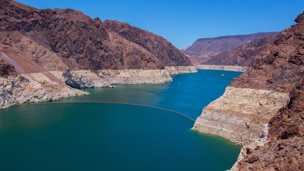
Lake Mead: The giant at the U.S.-Mexico border and its role in water curtailments
Colorado River Basin from the lens of the U.S.-Mexico Border (Pt.2)
Dams and lakes along the Colorado River are essential infrastructure for storing water that flows from the Rocky Mountains southwest until it reaches the Gulf of California (or Sea of Cortes, as it is known in Mexico). However, current drought conditions along the river are a wake-up call to basin members to implement mitigation efforts and water curtailments to support the sustainability of the river. In this blog, we will discuss the role and importance of Lake Mead in triggering water shortages, how water curtailments are distributed across members, how Mexico has helped the basin and recent developments to save the river.
Storage capacity, key players and current conditions
The entire basin on the U.S. side of the border can store close to 60 million acre-feet (MAF) (74,008 hm3) of water. This storage capacity is driven by two key reservoirs: Lake Mead, formed by the construction of the Hoover Dam, and Lake Powell, formed by the Glen Canyon Dam.[1] The two reservoirs provide 90% of the Colorado River system storage capacity and are the two largest reservoirs in the United States.
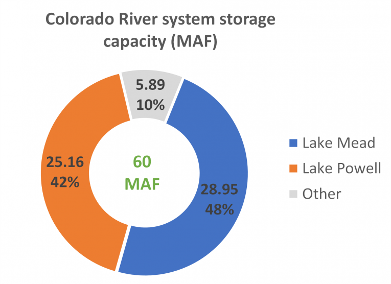
Source: NADBank staff based on data from the U.S. Bureau of Reclamation (USBR) available here
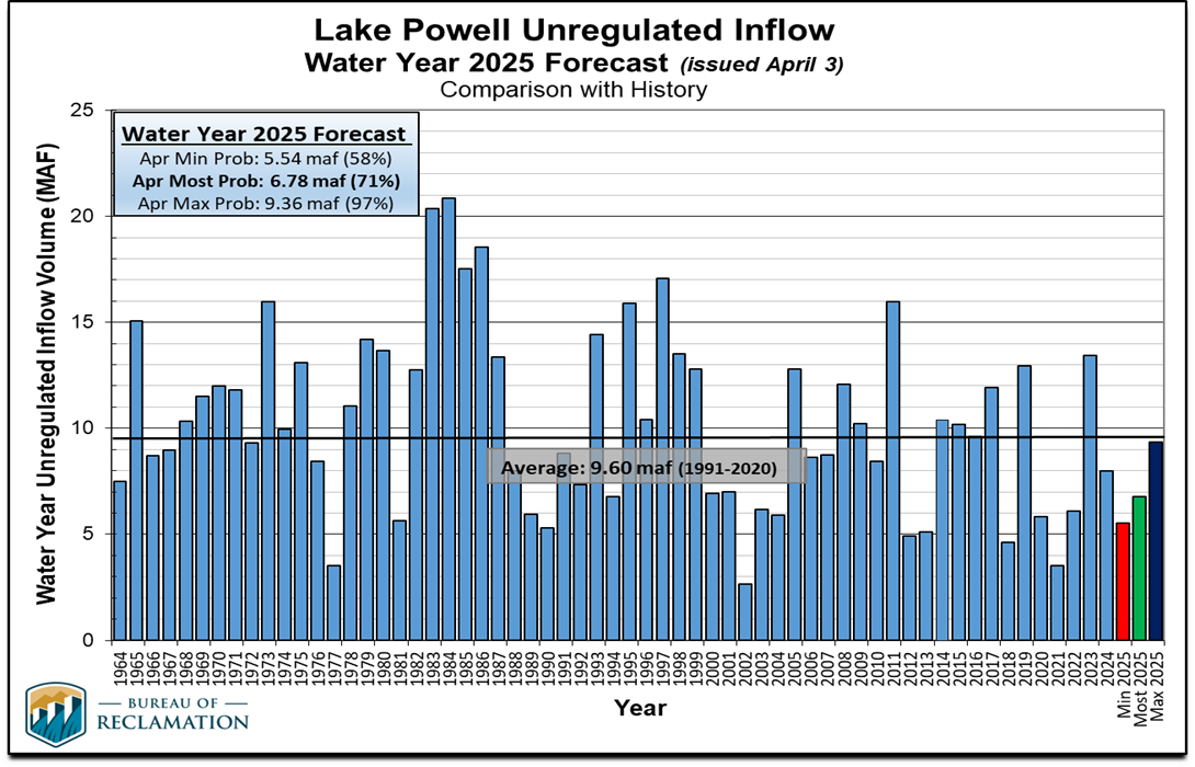
Both reservoirs are under severe droughts, with Lake Powell only 34% full and Lake Mead at 37% capacity as of October 2023. Below is an illustration of the reservoirs in the upper basin published monthly by the Central Arizona Project (CAP). This 336-mile-long canal conveys water from the Colorado River to southern Arizona (shown in red in the map).
Major Dams in the Colorado River Basin: Storage and Elevation Levels
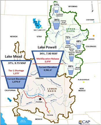
Source: CAP, Data as of March 4, 2024. Available in the agenda packet of Board meeting held March 7, 2024, here
What is the role of Lake Mead in shortage declarations?
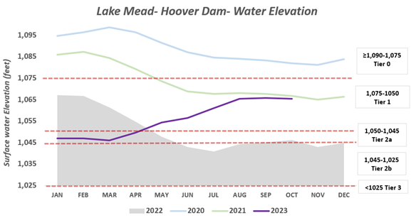
Under the 2007 Colorado River Interim Guidelines (effective until December 2026), mitigation procedures were established to protect Lake Mead and Lake Powel and to address their critical levels, drought conditions and growing water demands. The guidelines include pre-established water cuts for the lower basin states (Arizona, California and Nevada) based on fixed elevations at Lake Mead. These elevations refer to the height of the water above mean sea levels.
Specific elevations in Lake Mead trigger water cuts for Lower Basin states. The lower the elevation, the more severe the cuts will be. In August of each year, the 24-month study projections predict elevation levels for Lake Mead, Lake Powell, and other dams for the subsequent two years. These estimates indicate whether Lower Basin states will be subject to water cuts starting January 1st. The decisions are based only on the elevation forecast of Lake Mead.
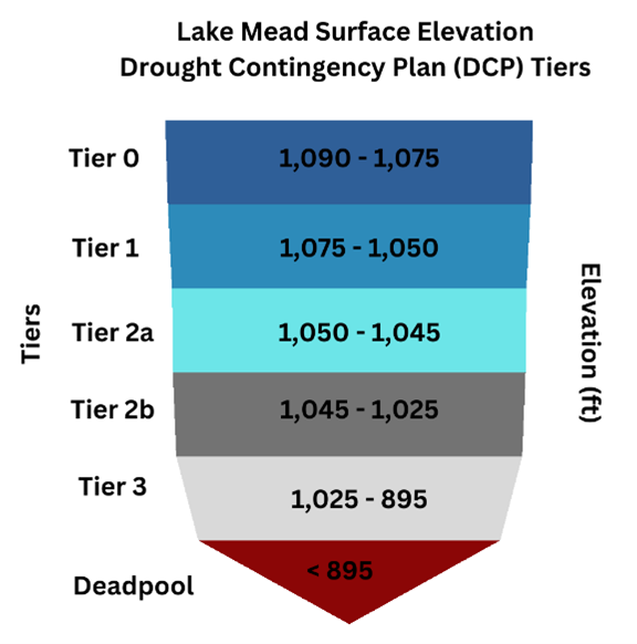
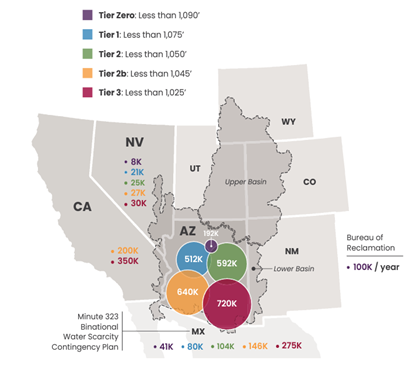
As concerns and evidence have grown over the health of the Colorado River, in 2019 new supplemental actions and additional water cuts were made to address the critical low levels at the reservoirs (see USBR 2019 Drought Contingency Plans). Currently, we have five sets of elevation tiers that can trigger shortages for the lower basin and Mexico. These tiers look like this:
Source: NADBank staff based on data from Central Arizona Project (CAP), available here
Are any shortage declarations in effect?
In the last three years, three shortage declarations were put in place for subsequent years following release of the August 24-month study projections, as elevation levels at Mead remain critical. Below are the current elevation levels for Lake Mead, where you can see how the reservoir has been struggling at low levels in recent years.
Source: NADBank staff based on data from the U.S. Bureau of Reclamation
How much less water do basin members receive after a shortage declaration?
The map below shows the water cuts for each Lower Basin state and Mexico per tier targets. For 2024 (starting January 1st), we expect the region to be at tier 1, with Mexico facing cuts of 80,000 acre-feet (AF) (~98.7hm3), Nevada with cuts of 21,000 AF and Arizona with the largest cuts of 512,000 AF of water.
Water Curtailment Volumes for Lower Basin States (CA, AZ, NV) and Mexico
Source: Central Arizona Project (CAP), available here
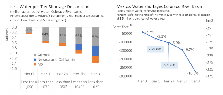
For 2024, water cuts at tier 1, will reach a total of 613,000 AF for lower basin states and Mexico. Under those circumstances, Arizona, with junior water rights from the Colorado River, bears the largest cut at around 84% of the total water curtailments in tier 1. Mexico, on the other hand, is reducing the use of Colorado River water by 80,000 AF (close to 100 hm3), representing 5.3% less water for Mexican users, most of whom are in the agriculture sector in Mexicali, Baja California. If the water elevation of Lake Mead continues to drop, water cuts will increase for basin members.
Source: NADBank staff estimates.
How has Mexico helped the basin?
Mexico has been part of the solution to address drier conditions in the Colorado River basin. In 2012, through Minute 319, the U.S. and Mexican Sections of the International Boundary and Water Commission (IBWC/CILA) addressed water shortages and environmental issues by considering water cuts for Mexico when elevation levels at Lake Mead reached certain levels.[2] In addition, in 2017, Mexico accepted additional curtailments to preserve Lake Mead (see the Binational Water Scarcity Contingency Plan in Minute 323), which are in effect until December 2026. As agreed, in both Minutes, total water cuts for Mexico when Lake Mead falls below 1,075 feet (above mean sea level) would be 80,000 AF (~99 hm3), equivalent to around 5.3% less water from the annual allocation for Mexico. These water cuts are in effect for Mexico in 2024.
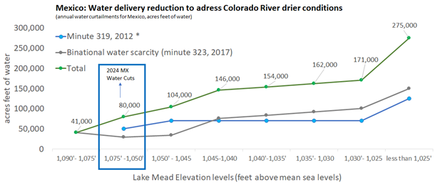
Source: NADBank staff based on Minute 319 and Minute 323.
Any additional efforts to support the river? Conservation of 3 MAF for the following years.
Despite joint efforts by the U.S. and Mexico for the Colorado River conservation, the prolonged drought and deteriorating conditions at Lake Mead and Lake Powell called for additional measures prior to the expiration of the Colorado River guidelines in December 2026. In May 2023, the Lower Basin states (CA, AZ, NV) reached an agreement to conserve at least 3 MAF of water by the end of 2026, including 1.5 MAF by 2024. Under this proposal, the federal government is expected to offer compensation for 2.3 MAF of water conserved using US$4 billion from the Inflation Reduction Act. The funds will support public entities and Indian tribes and will target compensation for voluntary, temporary, or multiyear diversion of water, reductions in water use, conservation efforts and habitat restoration.
What’s next?
A critical aspect of the Colorado River water is that it is mainly used for agricultural purposes at the U.S.-Mexico border in three vital agricultural hubs: Imperial Valley (CA), Yuma (AZ) and Mexicali Valley in Mexico. In the next few posts, we will discuss how the development of the agriculture sector took place at the U.S.-Mexico border, major water infrastructure projects, how water flows from the Rocky Mountains until it reaches the irrigation districts and some of the challenges, like salinity.
[1] Hoover Dam was authorized to be built in the Boulder Canyon Project Act of 1928. Glen Canyon dam was authorized to be built in the Colorado River Storage Project Act of 1956.
[2] Minutes are the agreements between the U.S. and Mexico regarding the implementation of the 1944 Water Treaty.
*The views expressed in the article belong solely to the author(s) and do not necessarily reflect the opinion or position of NADBank*
Post Categories: Water